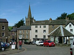
Alston, Cumbria
| Alston | |
|---|---|
 Alston town centre |
|
| Alston shown within Cumbria | |
| Population | 1,128 |
| OS grid reference | NY716462 |
| Civil parish | |
| District | |
| Shire county | |
| Region | |
| Country | England |
| Sovereign state | United Kingdom |
| Post town | ALSTON |
| Postcode district | CA9 |
| Dialling code | 01434 |
| Police | Cumbria |
| Fire | Cumbria |
| Ambulance | North West |
| EU Parliament | North West England |
| UK Parliament | |
Alston is a small town in Cumbria, England on the River South Tyne. It shares the title of the 'highest market town in England', at about 1,000 feet (300 m) above sea level, with Buxton, Derbyshire. Despite being at such an altitude and in remote location the town is easily accessible via the many roads which link the town to Weardale valley, Hartside Pass (and towns in Cumbria such as Penrith) as well as the Tyne valley. Historically part of Cumberland, Alston lies within the North Pennines, a designated Area of Outstanding Natural Beauty and is surrounded by beautiful views of the surrounding fells and the South Tyne Valley.
Alston lies within the North Pennines Area of Outstanding Natural Beauty, more than 15 miles (24 km) from the nearest town, and is surrounded by moorland. Nearby villages include Garrigill and Nenthead.
Situated at the crossroads/junction of the A686, A689 and B6277, the town lies on the confluence of the River South Tyne and the River Nent. On 18 May 2013 very heavy rain resulted in flooding in seven areas of Alston, affecting thirty-six properties. The Environment Agency records indicate that 51mm of rain fell that day.
The landscape of the area is built up from limestone, sandstone and shale. The area is rich in minerals, in particular lead deposits, and the landscape has been heavily influenced by the effects of varying methods of mining over the centuries.
...
Wikipedia

