Alpine National Park
|
Alpine National Park Victoria |
|
|---|---|
|
IUCN category II (national park)
|
|

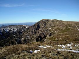
The summit of Mount Howitt taken from West Peak
|
|
| Nearest town or city | Omeo |
| Coordinates | m 37°20′15″S 146°45′24″E / 37.33750°S 146.75667°ECoordinates: m 37°20′15″S 146°45′24″E / 37.33750°S 146.75667°E |
| Established | 1989 |
| Area | 6,474 km2 (2,499.6 sq mi) |
| Managing authorities | Parks Victoria |
| Website | Alpine National Park |
| See also | Protected areas of Victoria |
The Alpine National Park is a national park located in the Central Highlands and Alpine regions of Victoria, Australia. The 646,000-hectare (1,600,000-acre) national park is located northeast of Melbourne. It is the largest National Park in Victoria, and covers much of the higher areas of the Great Dividing Range in Victoria, including Victoria's highest point, Mount Bogong at 1,986 metres (6,516 ft) and the associated subalpine woodland and grassland of the Bogong High Plains. The park's north-eastern boundary is along the border with New South Wales, where it abuts the Kosciuszko National Park. On 7 November 2008 the Alpine National Park was added to the Australian National Heritage List as one of eleven areas constituting the Australian Alps National Parks and Reserves.
Ecologically, alpine refers to areas where the environment is such that trees are unable to grow and vegetation is restricted to dwarfed shrubs, alpine grasses and ground-hugging herbs. In Victoria this is roughly those areas above 1,800 metres (5,900 ft) AHD . Below this is the sub-alpine zone, an area of open forest dominated by snow-gums, with significant areas of grasslands. This zone includes basins where cold air settles, restricting tree growth. In wetter areas these basins form Sphagnum bogs, which play an important role in the water cycle.
Water enters the alps as snow or rain. Bogs and frost hollows collect the water as snow melt and run off. A key element of these bogs is Sphagnum Moss, which acts as a sponge, absorbing up to twenty times its weight in water. These bogs then release the water over summer, ensuring creeks flow throughout most of the year maintaining the alps’ creeks and streams. The greatest risk to this system is damage to the Sphagnum bogs. Trampling by feral animals (pigs, cattle, horses, humans) reduces their ability to absorb and then release water; instead of a steady release, water flows increase significantly in spring, leading to erosion and scouring of river beds, and ceases over summer and autumn, leading to localised drought. Fire can remove riparian vegetation, also increasing run-off and erosion.
...
Wikipedia

