Alnashsky District
| Alnashsky District Алнашский район (Russian) Алнаш ёрос (Udmurt) |
|
|---|---|
 Location of Alnashsky District in the Udmurt Republic |
|
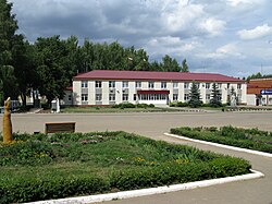
 View of Alnashi, the administrative center of the district |
|
|
|
|
| Location | |
| Country | Russia |
| Federal subject | Udmurt Republic |
| Administrative structure (as of July 2012) | |
| Administrative center | selo of Alnashi |
| Administrative divisions: | |
| selsoviet | 12 |
| Inhabited localities: | |
| Rural localities | 81 |
| Municipal structure (as of July 2005) | |
| Municipally incorporated as | Alnashsky Municipal District |
| Municipal divisions: | |
| Urban settlements | 0 |
| Rural settlements | 12 |
| Statistics | |
| Area | 896 km2 (346 sq mi) |
| Population (2010 Census) | 20,403 inhabitants |
| • Urban | 0% |
| • Rural | 100% |
| Density | 22.77/km2 (59.0/sq mi) |
| Time zone | SAMT (UTC+04:00) |
| Official website | |
| on | |
Alnashsky District (Russian: Ална́шский райо́н; Udmurt: Алнаш ёрос) is an administrative and municipal district (raion), one of the twenty-five in the Udmurt Republic, Russia. It is located in the south of the republic. The area of the district is 896 square kilometers (346 sq mi). Its administrative center is the rural locality (a selo) of Alnashi.
The district is bordered by Grakhovsky District of Udmurtia in the west, Mozhginsky District of Udmurtia in the north, also by Agryzsky District of the Republic of Tatarstan in the east and by Mendeleevsky District of Tatarstan in the south-west. The area of the district is 896 square kilometers.
The district is located in the Mozhga Hills that is a weak-high plain with calm character of relief. At the preagriculrural time in the vegetative cover fir-spruce forests with broad-leaved trees (lime tree, maple, oak, elm, common hazel) were dominated. At the present time second aspen-birchen and lime forests are dominated. The woodiness - 18,0 %.
...
Wikipedia


