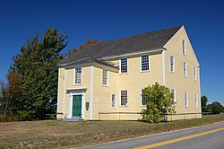
Alna Center, Maine
| Alna, Maine | ||
|---|---|---|
| Town | ||

Alna Meeting House, built in 1789
|
||
|
||
 Location in Lincoln County and the state of Maine. |
||
| Coordinates: 44°5′6″N 69°37′31″W / 44.08500°N 69.62528°W | ||
| Country | United States | |
| State | Maine | |
| County | Lincoln | |
| Settled | 1760 | |
| Incorporated | 1794 | |
| Government | ||
| • Type | Town Meeting | |
| Area | ||
| • Total | 21.32 sq mi (55.22 km2) | |
| • Land | 20.90 sq mi (54.13 km2) | |
| • Water | 0.42 sq mi (1.09 km2) | |
| Elevation | 128 ft (39 m) | |
| Population (2010) | ||
| • Total | 709 | |
| • Estimate (2012) | 709 | |
| • Density | 33.9/sq mi (13.1/km2) | |
| Time zone | Eastern (UTC-5) | |
| • Summer (DST) | Eastern (UTC-4) | |
| ZIP code | 04535 | |
| Area code(s) | 207 | |
| FIPS code | 23-01010 | |
| GNIS feature ID | 0582321 | |
| Website | http://alna.maine.gov | |
Alna is a town in Lincoln County, Maine, United States. The population was 709 at the 2010 census. Home to the Wiscasset, Waterville & Farmington Railway Museum, Alna includes the early mill village of Head Tide, noted for its historic architecture.
Originally a part of old Pownalborough, the town was settled around 1760 and incorporated in 1794 by the Massachusetts General Court as New Milford. But residents didn't like the name, so it was changed in 1811 to Alna, Latin for alder, the tree which grows in profusion along the banks of the Sheepscot River.
Alna was the site of the first fish hatchery in Maine, started shortly after the Civil War. Between 1895 and 1933, the narrow gauge Wiscasset, Waterville & Farmington Railway operated 3 stations in the town: Head Tide, Alna Center, and Sheepscot. The latter now serves as the base of operations for a heritage railway in town.
According to the United States Census Bureau, the town has a total area of 21.32 square miles (55.22 km2), of which, 20.90 square miles (54.13 km2) of it is land and 0.42 square miles (1.09 km2) is water. Alna is drained by the Sheepscot River.
The town in crossed by Maine State Route 194 and Maine State Route 218. It borders the towns of Wiscasset to the south, Dresden to the west, Pittston, Whitefield and Jefferson to the north, and across the Sheepscot River, Newcastle to the east.
...
Wikipedia

