Alloway Township, New Jersey
| Alloway Township, New Jersey | |
|---|---|
| Township | |
| Township of Alloway | |

|
|
 Alloway Township highlighted in Salem County. Inset map: Salem County highlighted in the State of New Jersey. |
|
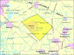
 Census Bureau map of Alloway Township, New Jersey |
|
| Coordinates: 39°33′44″N 75°18′38″W / 39.562311°N 75.310603°WCoordinates: 39°33′44″N 75°18′38″W / 39.562311°N 75.310603°W | |
| Country | |
| State |
|
| County | Salem |
| Royal charter | June 17, 1767 as Upper Alloways Creek Township |
| Incorporated | February 21, 1798 |
| Renamed | February 21, 1884 as Alloway Township |
| Named for | Native American Chief Alloway |
| Government | |
| • Type | Township |
| • Body | Township Committee |
| • Mayor | P. Ed McKelvey (term ends December 31, 2016) |
| • Clerk | Charlet Cheeseman |
| Area | |
| • Total | 33.834 sq mi (87.630 km2) |
| • Land | 33.402 sq mi (86.510 km2) |
| • Water | 0.432 sq mi (1.120 km2) 1.28% |
| Area rank | 71st of 566 in state 6th of 15 in county |
| Elevation | 62 ft (19 m) |
| Population (2010) | |
| • Total | 3,467 |
| • Estimate (2015) | 3,376 |
| • Rank | 433rd of 566 in state 9th of 15 in county |
| • Density | 103.8/sq mi (40.1/km2) |
| • Density rank | 542nd of 566 in state 10th of 15 in county |
| Time zone | Eastern (EST) (UTC-5) |
| • Summer (DST) | Eastern (EDT) (UTC-4) |
| ZIP code | 08001 |
| Area code(s) | 856 exchanges: 339, 878, 935 |
| FIPS code | 3403300880 |
| GNIS feature ID | 00882131 |
| Website | www |
Alloway Township is a township in Salem County, New Jersey, United States. As of the 2010 United States Census, the township's population was 3,467, reflecting an increase of 693 (+25.0%) from the 2,774 counted in the 2000 Census, which had in turn declined by 21 (-0.8%) from the 2,795 counted in the 1990 Census. What is now Alloway was formally incorporated as Upper Alloways Creek Township by a Royal charter granted on June 17, 1767, from portions of the now-defunct Alloways Creek Township. The township was formally incorporated by an act of the New Jersey Legislature on February 21, 1798. Quinton Township was formed from portions of the township on February 18, 1873. The name was officially changed to Alloway Township as of February 21, 1884.
The name Alloway is derivative of Allowas, a local Native American chief.
According to the United States Census Bureau, the township had a total area of 33.834 square miles (87.630 km2), including 33.402 square miles (86.510 km2) of land and 0.432 square miles (1.120 km2) of water (1.28%).
Alloway (with a 2010 Census population of 1,402) is a unincorporated community and census-designated place (CDP) located within Alloway Township. Other unincorporated communities, localities and place names located partially or completely within the township include Aldine, Alloway Junction, Dilkes Mile, Friesburg, Lake Sycamore, Mower, New Boston, Oakland, Penton, Remsterville, Riddleton and Watsons Mills.
...
Wikipedia
