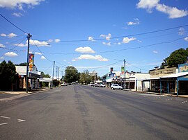
Allora
|
Allora Queensland |
|
|---|---|

Main street
|
|
| Coordinates | 28°02′S 151°59′E / 28.033°S 151.983°ECoordinates: 28°02′S 151°59′E / 28.033°S 151.983°E |
| Population | 889 (2011 census) |
| Postcode(s) | 4362 |
| Location | |
| LGA(s) | Southern Downs Region |
| State electorate(s) | Southern Downs |
| Federal Division(s) | Maranoa |
Allora is a town and locality in south-eastern Queensland, Australia, on the Darling Downs 158 kilometres (98 mi) south-west of the state capital, Brisbane. The town is in the Southern Downs Region. The township is located on the New England Highway between Warwick and Toowoomba. At the 2011 census, Allora had a population of 889.
The region surrounding this small farming community was first explored by Europeans in the 1840s; the town was surveyed in 1859. Its name is believed to derive from an Aboriginal word "gnarrallah", meaning waterhole or swampy place.
Following European settlement, the history of the area is entwined with two famous pastoral homesteads in the vicinity of Allora: Glengallan and Talgai . Both properties ran sheep.
The original "Talgai" run was taken up by E. E. Dalrymple in 1840. The creek that runs through Allora is named in his honour. Built in 1868 for the Clark family, Talgai Homestead stood on 300,000 acres (1,200 km²). The homestead is built of sandstone and covers sixty squares. It is now a bed and breakfast.
Allora Post Office opened on 31 March 1863.
The Allora State School opened on 1 May 1867.On 31 December 2008, it was renamed Allora P-10 State School.
From the 1870s, red cedar, pine and beech logged from the Goomburra valley were milled at Allora.
From 1869, Allora had its own local government (initially Borough of Allora, from 1903 Town of Allora). In 1915, it was merged with the surrounding Shire of Clifton to create the Shire of Allora, which was administered from the Shire's offices at 78 Herbert Street in Allora. In 1994, the Shire of Allora was amalgamated into the Shire of Warwick.
...
Wikipedia

