Alliance, Ohio
| Alliance, Ohio | |
|---|---|
| City | |

Glamorgan Castle
|
|
| Nickname(s): Carnation City | |
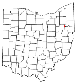
 Location of Alliance, Ohio |
|
 Location of Alliance in Stark County |
|
| Coordinates: 40°54′48″N 81°6′29″W / 40.91333°N 81.10806°WCoordinates: 40°54′48″N 81°6′29″W / 40.91333°N 81.10806°W | |
| Country | United States |
| State | Ohio |
| Counties | Stark, Mahoning |
| Government | |
| • Mayor | Alan Andreani |
| Area | |
| • Total | 8.96 sq mi (23.21 km2) |
| • Land | 8.92 sq mi (23.10 km2) |
| • Water | 0.04 sq mi (0.10 km2) |
| Elevation | 1,158 ft (353 m) |
| Population (2010) | |
| • Total | 22,322 |
| • Estimate (2012) | 22,183 |
| • Density | 2,502.5/sq mi (966.2/km2) |
| Time zone | Eastern (EST) (UTC-5) |
| • Summer (DST) | EDT (UTC-4) |
| ZIP code | 44601 |
| Area code(s) | 234 & 330 |
| FIPS code | 39-01420 |
| GNIS feature ID | 1064313 |
| Website | http://www.cityofalliance.com/ |
Alliance is a city in the U.S. state of Ohio. Most of the city is located in northeast Stark County while a small portion is in neighboring Mahoning County. The population was 22,322 as of the 2010 census. Alliance was established in 1854 by combining three smaller communities. The city was a manufacturing and railroad hub for much of the 20th century and is also associated with the state flower of Ohio, the scarlet carnation, and is known as "The Carnation City". The University of Mount Union, a private liberal arts college established in 1846, is located in Alliance.
Most of the city is part of the Canton–Massillon, OH Metropolitan Statistical Area, while the small portion of the city in Mahoning County is within the Youngstown–Warren–Boardman, OH-PA Metropolitan Statistical Area.
Alliance was founded in 1854 by the merger of three smaller communities called Williamsport (formed in 1827), Freedom (formed in 1838), and Liberty (formed in 1850). A fourth community, Mount Union, was added in 1888. Alliance was incorporated as a city in 1889.
There are two popular theories regarding the origin of the city's name. One holds that it was chosen because of the "alliance" of three small settlements into a larger entity. The other theory says the name reflects the fact that two major railroad lines (the Cleveland and Wellsville Railroad and the Ohio and Pennsylvania Railroad) intersected in Alliance, once known as "The Crossing".
Alliance is a town where Main Street was originally laid out to bring traffic to the train station, the heart of the city's transportation hub. The railroads were central to industry and personal transportation, bringing in raw materials for factories and sending out finished goods. Due to this, Alliance is sometimes referred to as "The town where Main Street is a dead end."
Alliance is a town rich with social, industrial and railroad history, with the restored Glamorgan Castle, previous home of the owner of Morgan Engineering, the Haines House, a restored underground railroad home, and the Mabel Hartzell historic home. The name of Levi L. Lamborn, the man who cultivated the scarlet carnation, Ohio's state flower, can still be seen on the facade of a building in the old downtown district. The Richardsonian Romanesque stone house of the Devine family is currently being renovated. The historic downtown area is experiencing a gradual renaissance, with the opening of a Saturday Farmers' Market on Main Street near the historic Caboose, and the renovation of a storefront on Main Street as an art gallery and live performance space, joining a scattering of antique shops and other businesses.
...
Wikipedia
