Allhallows, Kent
| Allhallows | |
|---|---|
 |
|
| Allhallows shown within Kent | |
| Population | 1,676 (2011) |
| OS grid reference | TQ844783 |
| Civil parish |
|
| Unitary authority | |
| Ceremonial county | |
| Region | |
| Country | England |
| Sovereign state | United Kingdom |
| Post town | ROCHESTER |
| Postcode district | ME3 |
| Dialling code | 01634 |
| Police | Kent |
| Fire | Kent |
| Ambulance | South East Coast |
| EU Parliament | South East England |
| UK Parliament |
|
Allhallows is a village and civil parish on the Hoo Peninsula in Kent, England. Situated in the northernmost part of Kent, and covering an area of 23.99 km², the parish is bounded on the north side by the River Thames, and in the east by the course of Yantlet creek, now silted up. At the 2001 census the parish had a population of 1,649.
Allhallows village is in two parts: the ancient Hoo All Hallows and the 20th century holiday colony Allhallows-on-Sea.
Near to the village of Allhallows is Windhill Green. There used to be a hamlet on the site of Windhill Green, but all of the original buildings have been demolished. The name remains on the Ordnance Survey maps.
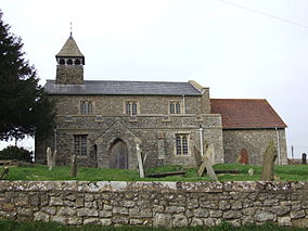
Hoo All Hallows is clustered round the parish church of All Saints, from which the village takes its name: Hallow meaning Saint. The Hoo (in 1285 written Ho) refers to a spur of land, and is thus a common element of place names on the spur or peninsula. Hoo All Hallows' parish registers date from 1629, and in 1841 the population was recorded as 268 people.
All Saints' Church itself dates from the 12th century. It is the only Grade I listed building on the Hoo Peninsula and is built of flint and stone with a lead roof. It has a west tower, north and south porches to the nave, and a chancel. The earliest part is the west end of the nave, followed by the south arcade. The north arcade dates from the early 13th century, while the chancel arch and screen are 14th century. Money was left in 1472 "to the werkes of the body of the church", possibly to the nave. The chancel was heavily restored in 1886–91. A notice in the church announces, "Previously scheduled for demolition under proposals for a London orbital international airport", referring to the 2004 putative Cliffe airport scheme.
A branch of the Pympe family lived on an estate with a mansion known as "Allhallows House".
Yantlet Creek was once part of a navigable and fortified trade route, used from Roman times. The Saxon Shore Way passes close by the old boundaries, indicating silting over many centuries.
...
Wikipedia

