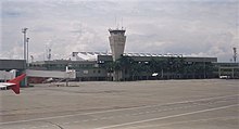
Alfonso Bonilla Aragón International Airport
|
Alfonso Bonilla Aragón International Airport Palmaseca International Airport |
|||||||||||
|---|---|---|---|---|---|---|---|---|---|---|---|
 |
|||||||||||
| Summary | |||||||||||
| Airport type | Public | ||||||||||
| Operator | Aerocali (Cali Aeronautical company) | ||||||||||
| Serves | Santiago de Cali, Palmira, Colombia | ||||||||||
| Elevation AMSL | 3,162 ft / 964 m | ||||||||||
| Coordinates | 3°32′30″N 76°22′55″W / 3.54167°N 76.38194°WCoordinates: 3°32′30″N 76°22′55″W / 3.54167°N 76.38194°W | ||||||||||
| Website | www |
||||||||||
| Map | |||||||||||
| Location of airport in Colombia | |||||||||||
| Runways | |||||||||||
|
|||||||||||
| Statistics (2015) | |||||||||||
|
|||||||||||
|
Sources: GCM Google Maps
|
|||||||||||
| Aircraft operations | 81,420 |
|---|---|
| Passengers | 5,122,389 |
| Cargo tonnage | 42,363 |
Alfonso Bonilla Aragón International Airport (IATA: CLO, ICAO: SKCL) also known as Palmaseca International Airport is an airport located between Palmira and Cali, the capital of Valle del Cauca Department, Colombia. It is Colombia's third largest airport in terms of passengers, transporting 3,422,919 in 2010. The airport often serves as the alternate airport for Bogotá - El Dorado Int'l Airport and other Colombian airports.
Alfonso Bonilla Airport is located in the broad Cauca River valley, which runs from south to north between the Western and Central Colombian Andes ranges. It is approximately 5 hours flight from Santiago de Chile, 50 minutes from Quito, Ecuador, and about 3 hours 18 minutes from Miami airport.
The airport has one runway, equipped with the following navigation aids: primary radar, secondary radar, ILS, ALS, PAPI, RVR, runway centerline lights, threshold lights, and taxiway lights. The airport has a SEI IX protection.
The Cali non-directional beacon (Ident: AS) is located 0.59 nautical miles (1.09 km) off the Runway 01 approach threshold. The Cali VOR-DME (Ident: CLO) is located 7.78 nautical miles (14.41 km) off the Runway 01 threshold.
...
Wikipedia

