Alexandria, Louisiana metropolitan area
| Alexandria, Louisiana metropolitan area | |
|---|---|
|
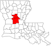
Map of Louisiana highlighting the Alexandria metropolitan area |
|
| Website | http://cityofalexandriala.com/ |
The Alexandria Metropolitan Statistical Area is a metropolitan area in central Louisiana that covers two parishes – Rapides and Grant. As of the 2000 census, the MSA had a population of 145,035 (though a July 1, 2009 estimate placed the population at 154,101).
The Alexandria metropolitan area was first defined in 1973. Then known as the Alexandria Standard Metropolitan Statistical Area (Alexandria SMSA), it consisted of two parishes - Rapides and Grant - and had a population of 131,749. By the census of 1980, the population had grown to 151,985, a 15% increase over the previous census.
In 1983, the official name was shortened to the Alexandria Metropolitan Statistical Area (Alexandria MSA), which is still in use to date. That same year, Grant Parish was removed from the MSA, leaving only Rapides Parish. A total of 135,282 people lived in Rapides Parish in 1980. That number had declined to 131,556 by 1990 and 126,337 in 2000.
Grant Parish was again added to the Alexandria MSA in 2003.
As of the census of 2000, there were 153,922 people, 56,193 households, and 40,083 families residing within the MSA. The racial makeup of the MSA was 68.95% White, 24.04% African American, 1.56% Native American, 1.27% Asian, 0.13% Pacific Islander, 0.82% from other races, and 1.25% from two or more races. Hispanic or Latino of any race were 6.35% of the population.
...
Wikipedia

