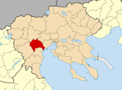
Alexandreia, Greece
|
Alexandreia Αλεξάνδρεια |
|
|---|---|
| Coordinates: 40°38′N 22°27′E / 40.633°N 22.450°ECoordinates: 40°38′N 22°27′E / 40.633°N 22.450°E | |
| Country | Greece |
| Administrative region | Central Macedonia |
| Regional unit | Imathia |
| Area | |
| • Municipality | 478.8 km2 (184.9 sq mi) |
| • Municipal unit | 140.6 km2 (54.3 sq mi) |
| Elevation | 6 m (20 ft) |
| Population (2011) | |
| • Municipality | 41,570 |
| • Municipality density | 87/km2 (220/sq mi) |
| • Municipal unit | 20,417 |
| • Municipal unit density | 150/km2 (380/sq mi) |
| Community | |
| • Population | 15,864 (2011) |
| Time zone | EET (UTC+2) |
| • Summer (DST) | EEST (UTC+3) |
| Postal code | 59300 |
| Area code(s) | 23330 |
| Vehicle registration | ΗΜ |
| Website | http://www.alexandria.gr |
Alexandreia or Alexandria (Greek: Αλεξάνδρεια [ale'ksaŋðria], before 1953: Γιδάς [ʝi'ðas]- Gidas) is a city in the Imathia regional unit of Macedonia, Greece. Its population was 14,821 at the 2011 census. Alexandreia is a rapidly developing city focusing to boost its economy through agriculture, merchandising, alternative tourism and other alternative actions.
Alexandreia is a located in the vast plain north of the river Aliakmonas and west of the river Axios, named Kampania or also Roumlouki. Its economy is chiefly based on the agricultural utilization of the surrounding fields. The area around Alexandreia has the greatest production of peaches in Greece and apples, pears, tobacco, and cotton are also grown at large. Its elevation is 10 m above mean sea level. Alexandreia is 19 km south of Giannitsa, 23 km northeast of Veroia and 42 km west of Thessaloniki.
Alexandreia has a railway station on the railway from Thessaloniki to Florina. The Platy railway station on the important railway from Thessaloniki to Athens is also situated in the municipality of Alexandreia. The motorways A2 (Egnatia Odos) and A1 pass through the municipality. The Greek National Roads EO1 and EO4 pass through the town.
...
Wikipedia


