Alento (Campania)
| Alento | |
|---|---|

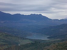
Alento reservoir seen from Monteforte Cilento
|
|
| Country | Italy |
| Basin features | |
| Main source |
Le Corne mountain, Gorga 894 m (2,933 ft) 40°19′9.66″N 15°13′58.04″E / 40.3193500°N 15.2327889°E |
| River mouth |
Tyrrhenian Sea, between Marina di Casalvelino and Velia 40°9′49.46″N 15°8′35.7″E / 40.1637389°N 15.143250°ECoordinates: 40°9′49.46″N 15°8′35.7″E / 40.1637389°N 15.143250°E |
| Basin size | 415 km2 (160 sq mi) |
| Physical characteristics | |
| Length | 36 km (22 mi) |
| Discharge |
|
The Alento is a river in southwestern Italy. Originating from Le Corne mountain, nearby the village of Gorga, it flows in the Campanian territory of Cilento, in the Province of Salerno. Its mouth is on the Tyrrhenian Sea, close to the Ancient Greek town of Velia, at the borders between the municipalities of Casal Velino and Ascea.
Originally named Alentum, the Latin word Cis Alentum (i.e.: "On this side of the Alento") is the origin of the toponym "Cilento". The river was mentioned by Strabo, into the Geographica, and by Cicero, who defined it noble.
After its origin in Gorga (a frazione of Stio), the river flows in a large valley crossing the municipal territories of Magliano Vetere and Monteforte Cilento. After it, between the territories of Cicerale, Prignano Cilento and Perito (at Ostigliano) the river forms a reservoir serving a dam. After the dam and a nature park it crosses the municipalities of Rutino, Lustra, Omignano (at Omignano Scalo), Salento, Castelnuovo Cilento (through the villages of Vallo Scalo and Velina), Casal Velino and Ascea. The mouth is located between Marina di Casalvelino and Velia.
...
Wikipedia
