Aldingen
| Aldingen | ||
|---|---|---|
|
||
| Coordinates: 48°05′40″N 08°42′21″E / 48.09444°N 8.70583°ECoordinates: 48°05′40″N 08°42′21″E / 48.09444°N 8.70583°E | ||
| Country | Germany | |
| State | Baden-Württemberg | |
| Admin. region | Freiburg | |
| District | Tuttlingen | |
| Government | ||
| • Mayor | Reinhard Lindner | |
| Area | ||
| • Total | 22.17 km2 (8.56 sq mi) | |
| Elevation | 650 m (2,130 ft) | |
| Population (2015-12-31) | ||
| • Total | 7,516 | |
| • Density | 340/km2 (880/sq mi) | |
| Time zone | CET/CEST (UTC+1/+2) | |
| Postal codes | 78554 | |
| Dialling codes | 07424 | |
| Vehicle registration | TUT | |
| Website | www.aldingen.de | |
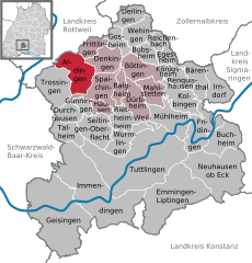
Aldingen is a municipality in the district of Tuttlingen in Baden-Württemberg in Germany.
Aldingen lies on the eastern edge of the Baar region at the foot of the Swabian Jura, and within sight of the Dreifaltigkeitsberg (Holy Trinity Mountain). The Prim, which joins the Neckar (a tributary of the Rhine) in Rottweil, passes through Aldingen.
Balgheim is bordered by the city of Rottweil as well as Frittlingen to the north, Denkingen to the east, the city of Spaichingen to the south, and the city of Trossingen, as well as Deisslingen in the district Rottweil, to the west.
The ending of the town name (-ingen) indicates that Aldingen has its roots in the territory of Alamannia. During the restoration of the Protestant Mauritius church, archaeological research resulted in the discovery of evidence that allows the origins of the town to be traced back to the 4th century AD. In addition, post holes dating back to around 700 AD were uncovered. In the late 11th century, this wooden church was replaced by one built of stone.
The town was first mentioned in official documents in 802 in a deed of gift of the Abbey of Saint Gall. In 1444 Aldingen joined the Duchy of Württemberg, and became Protestant during the Reformation.
Aldingen belongs to the Amt Spaichingen.
...
Wikipedia


