Albufeira Municipality
| Albufeira, Portugal | |||
|---|---|---|---|
| Municipality | |||

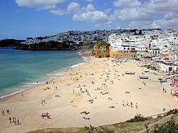
Praia dos Pescadores in the municipality of Albufeira
|
|||
|
|||
 |
|||
| Coordinates: 37°5′23″N 8°14′45″W / 37.08972°N 8.24583°WCoordinates: 37°5′23″N 8°14′45″W / 37.08972°N 8.24583°W | |||
| Country |
|
||
| Region | Algarve | ||
| Subregion | Algarve | ||
| Intermunic. comm. | Algarve | ||
| District | Faro | ||
| Parishes | 4 | ||
| Government | |||
| • President | Carlos Eduardo da Silva e Sousa (PSD) | ||
| Area | |||
| • Total | 140.66 km2 (54.31 sq mi) | ||
| Lowest elevation | 0 m (0 ft) | ||
| Population (2011) | |||
| • Total | 40,828 | ||
| • Density | 290/km2 (750/sq mi) | ||
| Time zone | WET/WEST (UTC+0/+1) | ||
| Postal code | 8200 | ||
| Area code | 289 | ||
| Patron | Nossa Senhora da Conceição | ||
| Website | http://www.cm-albufeira.pt/ | ||
Albufeira (Portuguese pronunciation: [aɫβuˈfejɾɐ]) is a city, seat and municipality in the district of Faro, in the southernmost Portuguese region of the Algarve. The municipality population in 2011 was 40,828, in an area of 140.66 square kilometres (54.31 square miles). The city proper had a population of 13,646 in 2001. It is 250 kilometres (160 mi) from Lisbon, and is within close proximity of Paderne Castle. Lagos is located 30 kilometres (19 mi) to the west, and Faro 45 kilometres (28 mi) to the south-east. A tourist destination (due to its coastal conditions), Albufeira expands to approximately 300,000 residents during the summer and during New Year celebrations, owing to the number of hotels and lodgings in the district, that includes marina facilities, golf courses, restaurants and bars for the annual flood of visitors.
It is unclear when the first settlements specifically formed in the region of Albufeira, although scientific research suggest origins during the pre-historic epoch, and that the town of Albufeira formed as an out-port of the maritime fishery. The primitive settlement was occupied by the Romans, named it Baltum, introducing a centralized administrative structure and developing intense agricultural activities along with commerce. The Romans constructed aqueducts, roads and bridges, of which parts still remain.
The name originated from the Arab Al-buhera, which means castle of the sea, owing to its location along the coast, or alternately al-Buħayra, for the lagoon, in reference to the lagoon that formed in the lowlands. The Arabs constructed strong defensive structures, making the area almost impregnable, allowing this area to remain in the hands of their forces longer than other possessions in Portugal. The development of agriculture during this period was notable, with the introduction of new techniques and plant species. The Moors used the plow and fertilizers, as well as winches for lifting the water from the wells, introducing the irrigation of fields, constructing dams and transforming uncultivated areas into gardens and orchards.
...
Wikipedia


