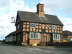
Albrighton, Bridgnorth
| Albrighton | |
|---|---|
 The Shrewsbury Arms |
|
| Albrighton shown within Shropshire | |
| Population | 4,326 (2011) |
| OS grid reference | SJ812041 |
| Civil parish |
|
| Unitary authority | |
| Ceremonial county | |
| Region | |
| Country | England |
| Sovereign state | United Kingdom |
| Post town | Wolverhampton |
| Postcode district | WV7 |
| Dialling code | 01902 |
| Police | West Mercia |
| Fire | Shropshire |
| Ambulance | West Midlands |
| EU Parliament | West Midlands |
| UK Parliament | |
Albrighton is a large village (population 4,157 in the 2001 census),(population increasing to 4,326 in the 2011 census) and civil parish in Shropshire, England. It is located 7.5 miles (12.1 km) northwest of Wolverhampton and is best described as a dormitory village for the city. It is 11.3 miles (18.2 km) from Bridgnorth and used to be within the now defunct Bridgnorth district; it is now part of the Shropshire Council unitary authority.
The village has a railway station, which is on the Shrewsbury to Wolverhampton Line. Very close by is RAF Cosford and the M54 motorway. The village is the most easterly settlement in Shropshire. Immediately to the north is the hamlet and parish of Donington separated from Albrighton by Humphreston (Albrighton) Brook.
Mentioned in the Domesday Book as Albricston(e) or the home/farm of Albric/Aethelbeorht, it received its charter in 1303, which was renewed in 1662 for rather unusual reasons. The charter declared that "because Albrighton (then) adjoined Staffordshire on the east, south and west sides, felons and other malefactors fled Staffordshire to escape prosecution because there was no resident justice of the peace in that part of Shropshire".
The parish church, dedicated to St Mary Magdalene was completed around 1181, and some rebuilding work was done in 1853. It is built of red sandstone in the Norman style. The church contains an alabaster monument to Sir Craig Wilson, as well as the Albrighton Mace donated to the village in 1663, by Lady Mary Talbot. The east window of the church dates from the 14th century.
...
Wikipedia

