Albert County, New Brunswick
| Albert | |
|---|---|
| County | |

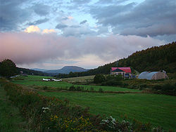
Farm landscape near Alma
|
|
 Location within New Brunswick |
|
| Coordinates: 45°49′N 64°51′W / 45.82°N 64.85°WCoordinates: 45°49′N 64°51′W / 45.82°N 64.85°W | |
| Country |
|
| Province |
|
| Established | 1845 |
| Area | |
| • Land | 1,806.54 km2 (697.51 sq mi) |
| Population (2011) | |
| • Total | 28,846 |
| • Density | 16.0/km2 (41/sq mi) |
| • Pop 2006-2011 |
|
| • Dwellings | 12,573 |
| Time zone | AST (UTC-4) |
| • Summer (DST) | ADT (UTC-3) |
| Area code(s) | 506 |
Albert County (2011 population 28,846) is a county located in southeastern New Brunswick, Canada on Chignecto Bay in the Bay of Fundy. Prior to the abolition of county government in 1967, the shire town was Hopewell Cape. The county was established in 1845 from parts of Westmorland County and Saint John County, and named after Prince Albert.
There are four municipalities within Albert County (listed by 2011 population):
The county is subdivided into six parishes (listed by 2011 population):
Highways and numbered routes that run through the county, including external routes that start or finish at the county limits:
...
Wikipedia
