Alamo Square
| Alamo Square | |
|---|---|
| Neighborhood | |

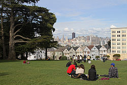
Looking across Alamo Square Park towards the famous "Painted Ladies" and city skyline
|
|
| Location within Central San Francisco | |
| Coordinates: 37°46′35″N 122°26′05″W / 37.776384°N 122.434709°WCoordinates: 37°46′35″N 122°26′05″W / 37.776384°N 122.434709°W | |
| Country |
|
| State |
|
| City and county | San Francisco |
| Government | |
| • Supervisor | London Breed |
| • Assemblymember | David Chiu (D) |
| • State senator | Scott Wiener (D) |
| • U. S. rep. | Nancy Pelosi (D) |
| Area | |
| • Total | 1.20 km2 (0.463 sq mi) |
| • Land | 1.20 km2 (0.463 sq mi) |
| Population (2008) | |
| • Total | 5,617 |
| • Density | 11,992/km2 (31,059/sq mi) |
| Time zone | Pacific (UTC-8) |
| • Summer (DST) | PDT (UTC-7) |
| ZIP codes | 94115, 94117 |
| Area codes | 415/628 |
Alamo Square is a residential neighborhood and park in San Francisco, California, in the Western Addition. Its boundaries are not well-defined, but are generally considered to be Webster Street on the east, Golden Gate Avenue on the north, Divisadero Street on the west, and Fell Street on the south.
Alamo Square Park, the neighborhood's focal point and namesake, consists of four city blocks at the top of a hill overlooking much of downtown San Francisco, with a number of large and architecturally distinctive mansions along the perimeter, including the "Painted Ladies", a well-known postcard motif. The park is bordered by Hayes Street to the south, Steiner Street to the east, Fulton Street to the north, and Scott Street to the west. Named after the lone cottonwood tree ("alamo" in Spanish), Alamo Hill, was a watering hole on the horseback trail from Mission Dolores to the Presidio in the 1800s. In 1856, Mayor James Van Ness created a 12.7 acre park surrounding the watering hole, creating "Alamo Square".
Alamo Square Park includes a playground and a tennis court, and is frequented by neighbors, tourists, and dog owners. On a clear day, the Transamerica Pyramid building and the tops of the Golden Gate Bridge and Bay Bridge can be seen from the park's center. The San Francisco City Hall can be seen directly down Fulton Street. The area is part of the city's fifth Supervisorial district and is served by several Muni bus lines, including the 5, 21, 22, and 24. In 2016 it was closed for a $4.3 million renovation lasting seven months.
The Alamo Square neighborhood is characterized by Victorian architecture that was left largely untouched by the urban renewal projects in other parts of the Western Addition. The Alamo Square area contains the second largest concentration of homes over 10,000 square feet (930 m2) in San Francisco, after the Pacific Heights neighborhood.
...
Wikipedia


