Alamance County
| Alamance County, North Carolina | |||
|---|---|---|---|

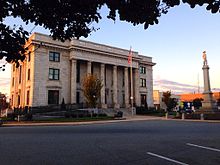
Alamance County Courthouse and Confederate Memorial
|
|||
|
|||
| Motto: Pro bono publico | |||
 Location in the U.S. state of North Carolina |
|||
 North Carolina's location in the U.S. |
|||
| Founded | January 29, 1849 | ||
| Named for | Native American word to describe the mud in Great Alamance Creek | ||
| Seat | Graham | ||
| Largest city | Burlington | ||
| Area | |||
| • Total | 435 sq mi (1,127 km2) | ||
| • Land | 424 sq mi (1,098 km2) | ||
| • Water | 11 sq mi (28 km2), 2.5% | ||
| Population (est.) | |||
| • (2015) | 158,276 | ||
| • Density | 356/sq mi (137/km²) | ||
| Congressional districts | 2nd, 4th, 6th | ||
| Time zone | Eastern: UTC-5/-4 | ||
| Website | www |
||
Alamance County ![]() i/ˈæləmæns/ is a county located in the U.S. state of North Carolina. As of the 2010 census, the population was 151,131. Its county seat is Graham. Formed in 1849 from Orange County to the east, Alamance County has been the site of significant historical events, textile manufacturing, and agriculture in North Carolina.
i/ˈæləmæns/ is a county located in the U.S. state of North Carolina. As of the 2010 census, the population was 151,131. Its county seat is Graham. Formed in 1849 from Orange County to the east, Alamance County has been the site of significant historical events, textile manufacturing, and agriculture in North Carolina.
Alamance County comprises the Burlington, NC Metropolitan Statistical Area, which is also included in the Greensboro-Winston-Salem-High Point, NC Combined Statistical Area. The 2012 estimated population of the metropolitan area was 153,920.
...
Wikipedia


