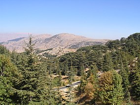
Al Shouf Cedar Nature Reserve
| Al Shouf Cedar Nature Reserve | |
|---|---|

Al Shouf Cedar Nature Reserve
|
|
|
Map of Lebanon
|
|
| Location | Chouf District, Lebanon |
| Coordinates | 33°41′39.25″N 35°42′07.63″E / 33.6942361°N 35.7021194°ECoordinates: 33°41′39.25″N 35°42′07.63″E / 33.6942361°N 35.7021194°E |
| Area | 550 km2 (210 sq mi) |
| Established | 1996 |
| http://www.shoufcedar.org/ | |
Al Shouf Cedar Nature Reserve is a nature reserve in the Chouf District of Lebanon. It is located on the slopes of Barouk mountain and has an area of 550 km2 (210 sq mi), nearly 5.3% of the Lebanese territory.
The reserve contains the Lebanon cedar forests of Barouk, Maaser el Shouf and Ain Zhalta-Bmohray. It is an Important Bird Area (IBA) and Eco-tourism area. It hosts 32 species of wild mammals, 200 species of birds, and 500 species of plants. The founder of the reserve is Walid Jumblatt.
The barouk mountain comprises rocks from the (Pliocene) which have undergone major tectonic movement that divided the mountains of Lebanon into two parallel parts; the eastern range is called the Anti-Lebanon, and the western range is called Mount Lebanon. The two mountain ranges are separated by the Beqaa Valley, which is composed of recent infill sediments. The main rocks are limestone. The whole of the Barouk Mountain is cavernous limestone, with many surface features such as dolines indicating the underlying cavernous forms of the mountain range. One particularly noteworthy cave, estimated to be 700 metres (2,300 ft) long, is located near Niha village. Villagers report an abundance of stalactites and stalagmites and that there is an underground body of water.
The highest peak on the range at 1,980 metres (6,500 ft). The trend from north to south is for the eastern slopes to change from very steep to less steep and for the western slopes to become increasingly steep. The top of the Barouk range becomes increasingly narrow towards the south.
Precipitation in the watershed is the source of both surface streamflow and groundwater. The major portion of this occurs as rain. Snowfall often occurs at the upper elevations but snow seldom persists more than a few days and disappears before the end of the rainy season. Normally snow has little overall direct effect on stream-flow within the watershed. However, on rare occasions warm rains falling on the snow-pack may result in rapid melting and release of large quantities of water at a time when the soils are already fully saturated. These conditions result in rapid runoff and floods. A large proportion of the exposed surface rock in the Barouk region is cavernous, fissured and broken limestone, and its porous condition makes it very permeable. This results in much of the precipitation infiltrating with minimum surface runoff despite the often-shallow soils and sparse vegetative cover. Water percolates downward through the various formations and feeds the many large springs found on lower slopes in the area. Such springs help maintain stream-flow during the April to November dry season. Surface water flows originating on the range are mostly seasonal but some are perennial. Underground water generates outflow rivers such as: - Al Awali River, more commonly known as Al-Barouk river - Damour River, known as Al-Safa river The summit of the range is considered as a divide between two hydrological systems because of the difference between the two slopes of the mountain. The eastern slope is much steeper and favors surface stream flows, whereas the western slope is less steep and favors ground water aquifers.
...
Wikipedia

