Akusekijima
| Native name: Japanese: 悪石島 | |
|---|---|

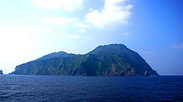
View from the ferry "TOSHIMA". May, 2007
|
|
| Geography | |
| Location | East China Sea |
| Coordinates | 29°27′06″N 129°36′04″E / 29.45167°N 129.60111°E |
| Archipelago | Tokara Islands |
| Area | 7.49 km2 (2.89 sq mi) |
| Length | 3.2 km (1.99 mi) |
| Width | 2.5 km (1.55 mi) |
| Coastline | 12.64 km (7.854 mi) |
| Highest elevation | 584 m (1,916 ft) |
| Highest point | Midake |
| Administration | |
|
Japan
|
|
| Demographics | |
| Population | 59 (2004) |
| Ethnic groups | Japanese |
Akusekijima (悪石島?), is one of the Tokara Islands, a sub-group of the Satsunan Islands belonging to Kagoshima Prefecture, Japan. The island, 7.42 km² in area, has a population of 59 persons. The island can only be reached by boat as it has no airport, there is a ferry service twice per week to the city of Kagoshima on the mainland. Travel time is about 11 hours. The islanders are dependent mainly on fishing and seasonal tourism.
Akusekijima is located 38 kilometres (21 nmi) southwest of Nakanoshima. The island has an area of approximately 7.49 square kilometres (2.89 sq mi) with a length of about 3.2 kilometres (2.0 mi) and a width of 2.5 kilometres (1.6 mi).Most of the island is surrounded by steep cliffs.
The island is an andesite – dacite stratovolcano formed by two summit crater, Biroyama (ビロ山?) 355.5 metres (1,166 ft) and Nakadake (中岳?). 464 metres (1,522 ft). Mitake (御岳山?) 584 metres (1,916 ft), the highest elevation on the island, is a lava dome. Lava flows in the northern portion of the island have been dated to 80,000 years ago. There has been no volcanic activity in historic times.
...
Wikipedia
