Aksu Prefecture
|
Aksu Prefecture 阿克苏地区 • ئاقسۇ ۋىلايىتى |
|
|---|---|
| Prefecture | |
| Chinese transcription(s) | |
| • Pinyin | Ākèsū Dìqū |
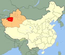
 Aksu Prefecture (red) in Xinjiang (orange) |
|
| Coordinates: 41°10′N 80°15′E / 41.167°N 80.250°E | |
| Country | People's Republic of China |
| Province | Xinjiang |
| County-level divisions | 8 |
| Municipal seat | Aksu |
| Area | |
| • Prefecture | 128,099 km2 (49,459 sq mi) |
| • Urban | 14,450 km2 (5,580 sq mi) |
| • Metro | 14,450 km2 (5,580 sq mi) |
| Elevation | 1,519 m (4,984 ft) |
| Population (2010 Census) | |
| • Prefecture | 2,370,887 |
| • Density | 19/km2 (48/sq mi) |
| • Urban | 535,657 |
| • Urban density | 37/km2 (96/sq mi) |
| • Metro | 535,657 |
| Time zone | China Standard (UTC+8) |
| Postal code | 843000 |
| Area code(s) | 997 |
| License Plate | 新N |
| Website | Aksu Prefecture Government |
Aksu Prefecture (simplified Chinese: 阿克苏地区; traditional Chinese: 阿克蘇地區; pinyin: Ākèsū Dìqū; Uyghur: ئاقسۇ ۋىلايىتى, Ақсу Вилайити, ULY: Aqsu Wilayiti, UYY: Ak̡su Vilayiti?) is located in mid-western Xinjiang, People's Republic of China. It has an area of 131,161 km2 (50,642 sq mi) and 2.37 million inhabitants at the 2010 census whom 535,657 lived in the built-up (or metro) area made up of Aksu urban district. The name Aksu is Turkic for 'white water'.
The prefecture occupies the northwestern part of the Tarim Basin and the southern slopes of the Tian Shan. The southern part of the prefecture is within the Taklamakan desert. Agriculture is only possible in the areas irrigated by the Tarim River and its glacier-fed tributaries, the Aksu River and the Muzart River.
...
Wikipedia
