Akitakata, Hiroshima
|
Akitakata 安芸高田市 |
|
|---|---|
| City | |

Akitakata city hall
|
|
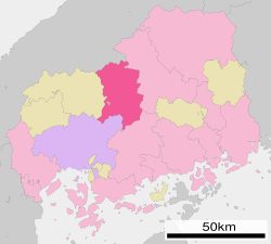
 Location of Akitakata in Hiroshima Prefecture |
|
| Location in Japan | |
| Coordinates: 34°39′47″N 132°42′23″E / 34.66306°N 132.70639°ECoordinates: 34°39′47″N 132°42′23″E / 34.66306°N 132.70639°E | |
| Country | Japan |
| Region | Chūgoku (San'yō) |
| Prefecture | Hiroshima Prefecture |
| Government | |
| • Mayor | Kazuyoshi Hamada (since April 2008) |
| Area | |
| • Total | 538.17 km2 (207.79 sq mi) |
| Population (April 1, 2011) | |
| • Total | 31,565 |
| • Density | 59/km2 (150/sq mi) |
| Symbols | |
| • Tree | Cherry blossom |
| • Flower | Hydrangea |
| Time zone | Japan Standard Time (UTC+9) |
| City hall address | Yoshidachō, Yoshida 791, Akitakata City, Hiroshima Prefecture (広島県安芸高田市吉田町吉田791) 731-0592 |
| Website | www |
Akitakata (安芸高田市 Akitakata-shi?) is a city located in north-central Hiroshima Prefecture, Japan.
As of April 1, 2011, the city has a population of 31,565, with 13,223 households and a population density of 59 persons per km². of The total area is 538.17 km².
The modern city of Akitakata was established on March 1, 2004, from the merger of the towns of Kōda, Midori, Mukaihara, Takamiya, Yachiyo and Yoshida (all from Takata District). Therefore, Takata District was dissolved as a result of this merger.
It is a mountainous farming area known for many traditional events as well as certain food products.
One such food product is Ebisu tea, a sweet fragrant tea, that comes from Mukaihara Town. Another is Yuzu juice (柚子ジュース), a product of the Kawane area of Takamiya town in the northeastern part of the city.
The city also lays claim to be the birthplace and hometown of Mori Motonari, the famous Warring States era daimyo of the 16th century.
The area of Akitakata City was originally known as Takata District (高田郡), which combined 26 villages into a single administrative unit on April 1, 1889.
...
Wikipedia

