Aisai, Aichi
|
Aisai 愛西市 |
|||
|---|---|---|---|
| City | |||

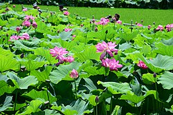
Morikawa lotus field
|
|||
|
|||
 Location of Aisai in Aichi Prefecture, highlighted in pink |
|||
| Coordinates: 35°9′N 136°44′E / 35.150°N 136.733°ECoordinates: 35°9′N 136°44′E / 35.150°N 136.733°E | |||
| Country | Japan | ||
| Region | Chūbu (Tōkai) | ||
| Prefecture | Aichi Prefecture | ||
| Area | |||
| • Total | 66.63 km2 (25.73 sq mi) | ||
| Population (February 2012) | |||
| • Total | 64,507 | ||
| • Density | 968/km2 (2,510/sq mi) | ||
| Time zone | Japan Standard Time (UTC+9) | ||
| - Tree | Podocarpaceae | ||
| - Flower | Nelumbo nucifera | ||
| Phone number | 0567-26-8111 | ||
| Address | Yoneno 308,Inaba-cho, Aisai-shi, Aichi-ken 496-8555 | ||
| Website | City of Aisai | ||
Aisai (愛西市 Aisai-shi?) is a city located in Aichi Prefecture, Japan.
As of 2012, the city has an estimated population of 64,507 and a population density of 968 persons per km². The total area is 66.63 km².
Aisai is located in the coastal flatlands of far western Aichi Prefecture, bordering Gifu Prefecture on the west. It has a short border with Mie Prefecture to the southwest. The Kiso River and the Nagara River pass through the city.
During the Edo period, the area of modern Aisai was controlled by the Yokoi clan, retainers of the Owari Tokugawa of Nagoya. During the Meiji period, the area was organized into several villages under Kasai District and Kaito District, Aichi Prefecture, which later became Ama District, Aichi in the Taisho period.
The modern city of Aisai was created through the merger on April 1, 2005 of Saya and Saori Towns and Hachikai and Tatsuta Villages.
...
Wikipedia


