Airport Road (Manila)
 |
|
|---|---|
| Nichols Road | |

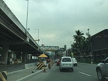
Andrews Avenue, looking west in Newport City with the elevated NAIA Expressway
|
|
| Length | 4.3 km (2.7 mi) |
| Location | Parañaque, Pasay, Taguig |
| West end | Roxas Boulevard in Baclaran |
| Major junctions |
Domestic Road Tramo Street (Aurora Boulevard) |
| East end | South Luzon Expressway in Fort Bonifacio |
Andrews Avenue is a major east-west thoroughfare in Metro Manila, Philippines that functions as a metropolitan linkage between Pasay and Taguig. It runs underneath the NAIA Expressway almost parallel to Epifanio de los Santos Avenue (EDSA) to the north connecting Roxas Boulevard and Domestic Road near Bay City with South Luzon Expressway near Newport City. It has an arterial extension continuing 3.4 kilometers (2 miles) northeast to Fifth Avenue and McKinley Road in Bonifacio Global City known as Lawton Avenue.
Andrews Avenue also serves as the main feeder to Ninoy Aquino International Airport from the east and west and is the main access road to Resorts World Manila.
The avenue was formerly called Nichols Field Road, later shortened to Nichols Road, after the US air base in Pasay which it served. Nichols Field, in turn, was named after Captain Henry E. Nichols, a US Navy commander of monitor ship USS Monadnock during the Philippine-American War. The air base was built in 1912 and the road to Fort McKinley (now Fort Bonifacio) and to Dewey Boulevard (now Roxas Boulevard) was constructed shortly thereafter. The whole stretch from Dewey to Fort McKinley was named Nichols Road.
...
Wikipedia
