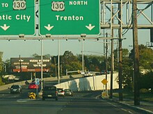
Airport Circle (Pennsauken)
| Airport Circle | |
|---|---|

View of Airport Circle from US 30 east
|
|
| Location | |
| Pennsauken Township, New Jersey | |
| Coordinates: | 39°56′01″N 75°04′57″W / 39.9335°N 75.0825°WCoordinates: 39°56′01″N 75°04′57″W / 39.9335°N 75.0825°W |
| Roads at junction: |
|
| Construction | |
| Type: | Traffic circle |
| Map | |
 |
|
The Airport Circle is a traffic circle in Pennsauken Township, New Jersey, United States. It is located at the intersection of Route 38, U.S. Route 30, and U.S. Route 130, close to the Camden border. South of the circle, Route 30 and Route 130 run concurrent until they reach the former Collingswood Circle in Collingswood. The Airport Circle opened in 1927 and is the first of is kind in the United States. It has been modified to include traffic lights and ramps to help move traffic through.
The Airport Circle is located in Pennsauken Township in Camden County, east of the city of Camden. The circle serves as the junction between US 30, US 130, Route 38, and CR 607 (Kaighns Avenue). From the circle, US 130 heads northeast on six-lane divided highway called Crescent Boulevard, US 30 continues west onto six-lane divided Admiral Wilson Boulevard, CR 607 runs west along two-lane undivided Kaighns Avenue, US 30 and US 130 continue south on six-lane divided Crescent Boulevard, and Route 38 heads to the east as a six-lane divided road, coming to an interchange with Route 70 a short distance later. All five roadways have ramps that feed into the circle itself, with traffic lights governing movements at the ramps from westbound Route 38, southbound US 130, and eastbound US 30 and a stop sign at the ramp from Kaighns Avenue. The ramp from westbound US 30/northbound US 130 merges into the main circle. The mainline of US 130 passes through the circle. There are flyover ramps that carry the mainline of US 30 through the circle. The eastbound US 30 ramp heads into the center of the circle, where a ramp for eastbound Route 38 splits and continues east over the circle to connect to that route. Eastbound US 30 merges with southbound US 130 in the median of that route. The flyover ramp carrying westbound US 30 forks to the right from northbound US 130 and heads to the east of the circle, passing over Route 38 before coming to a ramp connecting westbound Route 38 to westbound US 30. The ramp heads over US 130, with a ramp from the southbound direction of that route, before continuing west and merging with the ramp to US 30 westbound from the center of the circle. To the north of the circle is a residential neighborhood while the Airport Industrial Park is to the southeast. Other commercial and industrial establishments surround the circle to the northeast and west.
...
Wikipedia
