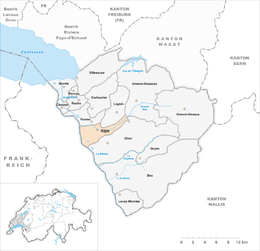
Aigle, Switzerland
| Aigle | ||
|---|---|---|
 |
||
|
||
| Coordinates: 46°19′N 6°58′E / 46.317°N 6.967°ECoordinates: 46°19′N 6°58′E / 46.317°N 6.967°E | ||
| Country | Switzerland | |
| Canton | Vaud | |
| District | Aigle | |
| Government | ||
| • Executive |
Municipalité with 5 members |
|
| • Mayor |
Syndic Frédéric Borloz FDP/PRD/PLR (as of 2016) |
|
| • Parliament |
Conseil communal with 70 members |
|
| Area | ||
| • Total | 16.41 km2 (6.34 sq mi) | |
| Elevation (la gare) | 405 m (1,329 ft) | |
| Population (Dec 2015) | ||
| • Total | 9,942 | |
| • Density | 610/km2 (1,600/sq mi) | |
| Demonym(s) | French: Les Aiglons | |
| Postal code | 1860 | |
| SFOS number | 5401 | |
| Localities | Le Cloître, Vers Pousaz, Fontanney | |
| Surrounded by | Vaud: Yvorne, Leysin, Ormont-Dessous, Ollon; Valais: Vouvry, Collombey-Muraz | |
| Twin towns | L'Aigle (France), Tübingen (Germany), Bassersdorf (Switzerland) | |
| Website |
www Profile (French), SFSO statistics |
|
Aigle (French for "eagle") is a historic town and a municipality and the capital of the district of Aigle in the canton of Vaud in Switzerland.
The official language of Aigle is (the Swiss variety of) French.
Aigle lies at an elevation of 415 m (1,362 ft) about 13 km (8.1 mi) south-southeast of Montreux. It is on the east edge of the Rhône valley, at the foot of the Swiss Alps.
Aigle has an area, as of 2009[update], of 16.41 square kilometers (6.34 sq mi). Of this area, 5.59 km2 (2.16 sq mi) or 34.1% is used for agricultural purposes, while 6.13 km2 (2.37 sq mi) or 37.4% is forested. Of the rest of the land, 4.2 km2 (1.6 sq mi) or 25.6% is settled (buildings or roads), 0.45 km2 (0.17 sq mi) or 2.7% is either rivers or lakes and 0.1 km2 (25 acres) or 0.6% is unproductive land.
Of the built up area, industrial buildings made up 5.2% of the total area while housing and buildings made up 6.6% and transportation infrastructure made up 9.0%. Power and water infrastructure as well as other special developed areas made up 1.5% of the area while parks, green belts and sports fields made up 3.4%. Out of the forested land, all of the forested land area is covered with heavy forests. Of the agricultural land, 21.5% is used for growing crops and 2.4% is pastures, while 10.2% is used for orchards or vine crops. Of the water in the municipality, 0.6% is in lakes and 2.1% is in rivers and streams.
Aigle includes the villages of Le Cloître, Vers Pousaz, and Fontanney. The surrounding municipalities are Yvorne, Leysin, Ormont-Dessous, and Ollon in the canton of Vaud, and Vouvry and Collombey-Muraz in the canton of Valais.
...
Wikipedia


