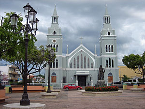
Aguada, Puerto Rico
| Aguada, Isla Encantada | |||
|---|---|---|---|
| Municipality | |||

The main plaza and the Catholic Church of Aguada
|
|||
|
|||
| Nickname(s): "La Villa de Sotomayor", "Ciudad Del Descubrimiento", "Villa de San Francisco de Asís de la Aguada", "El Pueblo Playero", "La Ciudad del Vaticano" | |||
| Anthem: "Muchos siglos han pasado" | |||
 Location of Aguada in Puerto Rico |
|||
| Coordinates: 18°22′46″N 67°11′18″W / 18.37944°N 67.18833°WCoordinates: 18°22′46″N 67°11′18″W / 18.37944°N 67.18833°W | |||
| Country |
|
||
| Territory |
|
||
| Founded | 1508 | ||
| Government | |||
| • Mayor | Manuel "Gabina" Santiago Mendoza (PNP) | ||
| • Senatorial dist. | 4 - Mayagüez | ||
| • Representative dist. | 18 | ||
| Population (2010) | |||
| • Total | 41,959 | ||
| Demonym(s) | Aguadeños | ||
| Time zone | AST (UTC-4) | ||
| Zip code | 00602 | ||
| Website | aguada.gov.pr | ||
Aguada (/əˈɡwɑːdə/; Spanish: [aˈɣwaða], Watered) is a municipality of Puerto Rico, located in the western coastal valley region bordering the Atlantic Ocean, east of Rincón, west of Aguadilla and Moca; and north of Anasco and Mayaguez. It is part of the Aguadilla-Isabela-San Sebastián Metropolitan Statistical Area. Aguada's population is spread over 17 wards and Aguada Pueblo, which is the downtown area and the administrative center of the city.
According to sources, a Taíno settlement called Aymamón was located close to the Culebrinas River. Although there is dispute to it, some sources believe that Christopher Columbus entered the island of Puerto Rico through Aguada on his second voyage in November 1493. The nearby city of Aguadilla also claims to be the site of Columbus' arrival. While there is no specific historical proof, it is known that many of the first attempts to set up a town on the island were in Aguada.
...
Wikipedia


