Agoura Hills, CA
| Agoura Hills, California | |
|---|---|
| General law city | |
| City of Agoura Hills | |

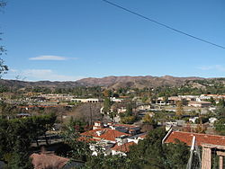
View of Agoura Hills looking from southern edge of the Historic Quarter in December 2006.
|
|
| Motto: "The Gateway to the Santa Monica Mountains" | |
 Location of Agoura Hills in California |
|
| Location in the United States | |
| Coordinates: 34°9′12″N 118°45′42″W / 34.15333°N 118.76167°WCoordinates: 34°9′12″N 118°45′42″W / 34.15333°N 118.76167°W | |
| Country | |
| State |
|
| County |
|
| Settled (by the Spanish) | 1700s |
| Incorporated | December 8, 1982 |
| Government | |
| • Type | City Council/City Manager |
| • Mayor | Harry Schwartz |
| • Mayor pro tem | Denis Weber |
| Area | |
| • Total | 7.822 sq mi (20.260 km2) |
| • Land | 7.793 sq mi (20.184 km2) |
| • Water | 0.029 sq mi (0.076 km2) 0.37% |
| Elevation | 922 ft (281 m) |
| Population (April 1, 2010) | |
| • Total | 20,330 |
| • Estimate (2013) | 20,681 |
| • Density | 2,600/sq mi (1,000/km2) |
| Time zone | Pacific Time Zone (UTC-8) |
| • Summer (DST) | PDT (UTC-7) |
| ZIP codes | 91301, 91376, 91377 |
| Area code | 747/818 |
| FIPS code | 06-00394 |
| GNIS feature IDs | 1667896, 2409666 |
| Website | www |
Agoura Hills is a city in Los Angeles County, California. Its population was estimated to be at 20,843 in 2014, up from 20,537 at the 2000 census. It is in the eastern Conejo Valley between the Simi Hills and the Santa Monica Mountains. The city is on the border between the county of Los Angeles to the east, west and south and Ventura County to the north. It is about 30 miles (48 km) northwest of Downtown Los Angeles and less than 10 miles (16 km) west of the Los Angeles City limits (Woodland Hills). Agoura Hills and unincorporated Agoura sit next to Calabasas, Oak Park, and Westlake Village.
The area was first settled by the Chumash Native Americans around 10,000 years ago. As the Alta California (Upper California) coast was settled by Spanish Franciscan missionaries in the late 18th century, the El Camino Real (the Royal Road or King's Highway), a road from Loreto, Baja California, Mexico to Sonoma, California, and connecting the Spanish missions in California, was established through the heart of what would later be known as Agoura Hills.
In about 1800, Miguel Ortega was granted a Spanish grazing concession called Rancho Las Virgenes or El Rancho de Nuestra Señora La Reina de Las Virgenes. The grant was abandoned after Ortega's death in 1810, and José Maria Dominguez was given Rancho Las Virgenes as a Mexican land grant in 1834. Maria Antonia Machado de Reyes purchased the rancho from Dominguez in 1845. (The "Reyes Adobe" ranch headquarters sits today in central Agoura Hills, where it is part of the Reyes Adobe Museum built around 2004 and owned by the Los Angeles County Parks and Recreation Department.)
...
Wikipedia

