Achadinha de Baixo
| Achadinha de Baixo | |
|---|---|
| Neighborhood | |

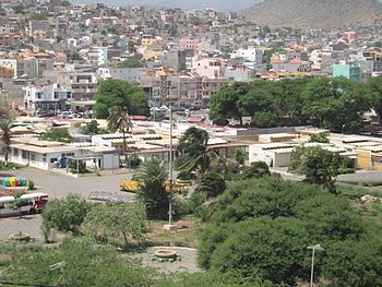
View of Achadinha de Baixo (in the upper right) from the Plateau with the Sucupira Market
|
|
| Country | Cape Verde |
| Island | Santiago Island |
| City | Praia |
| Developed | 1960s |
| Postal code | 7600 |
| Website | www.cmpraia.cv |
Achadinha de Baixo or simply Achadinha is a neighborhood in the northern part of the city of Praia, Cape Verde. The etymology of Achadinha is a small volcanic plateau.
It is bounded with Craveiro Lopes in the south, Fazenda in the east, Eugênio Lima in the west and a river, the Ribeira da Trindade separaing Calabaceira in the north.
Its size is about 25 to 30 ha, its length ranges from 500 meters in the east to 680 meters, the widest in the west and its width ranges from nearly 380 meters in the south to about 450 meters directly east-west to 500 meters within the stream in the north as its widest.
The lowest point is 12 meters at the road ramps with Eugénio Lima, 19 meters at the roundabout near the creek, 26 meters in the middle, 28 meters in the north, 33 meters in the northwest, both near the creek, and 45 meters in the west the highest is about 55 meters in the southwest, the remaining two near Eugénio Lima.
Housing developments occurred in around the 1950s. The neighborhood has houses without any architecture and there were no paved or cobblestone streets except for the main ones, the southwestern part started to have its streets paved and now only half are paved or with cobblestone. The majority of the inhabitants were low class. The urban development in 2010 in the westernmost section became fully developed
Achadinha de Baixo has a health center which it its nearest located in nearby Craveiro Lopes. The nearest fire station is at the border with Fazenda inside that subdivision.
It has a small sports complex used for futsal, volleyball and basketball, it is an outdoor facility.
One main street in the north named Rodovía de Ribeira de Trindade or Rodovía a Caralho a Quatro
Panoramics include the middle, the north and parts of the east of the Praia area including the Plateau and Achada Grande Frente, also the south can be seen, but parts of the west are not seen as nearby hills do not offer views.
Two transit line passes in the westernmost portion, they include:
One notable person was Lela Violão (1929-2009) who lived in the neighborhood for a part of his life.
Coordinates: 14°55′37″N 23°30′42″W / 14.927°N 23.5117°W
...
Wikipedia
