Acatlán de Juárez
| Acatlán de Juárez | |
|---|---|
| Municipality and city | |
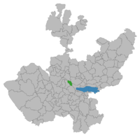
 Location of the municipality in Jalisco |
|
| Location in Mexico | |
| Coordinates: 20°14′N 103°32′W / 20.233°N 103.533°WCoordinates: 20°14′N 103°32′W / 20.233°N 103.533°W | |
| Country |
|
| State | Jalisco |
| Area | |
| • Total | 166.68 km2 (64.36 sq mi) |
| Elevation | 1,393 m (4,570 ft) |
| Population (2005) | |
| • Total | 22,540 |
Acatlán de Juárez is a town and municipality, in Jalisco in central-western Mexico. The municipality covers an area of 166.68 km².
As of 2005, the municipality had a total population of 22,540.
The first settlers in the region were members of a tribe that was established in Cocula, They were defeated by the Purepecha in 1509.
In the year of 1550 the area for the first time attained the first level of a municipality, under the power of the viceroy of the New Spain, Antonio de Mendoza. During his rule he encountered discontent with people in Zacoalco de Torres, Ahualulco and Ameca. In the first half of the 17th century the Augustinians built a temple dedicated to Santa Ana, known today as the " Parroquia de Santa Ana".
In 1825 the area fell under the canton of Sayula. In 1858, Benito Juárez, in his journey through these lands, stayed at the inn in the town of Acatlán de Juárez, owned by Miguel Gomez. During his short stay, he was killed at the hands of the conservatives, and died saving the pastor of the place, Meliton Gutierrez Vargas. On March 22 of 1906, by decree 1158, the name of the earlier village changed its name from Santa Ana Acatlan to Acaltán de Juarez, and acquired the title of a town.
Acatlán de Juárez is located in the centre of Jalisco state between the coordinates 20° 14'30" north latitude and 103° 32'30" west longitude at an altitude of 1,393 metres above sea level.
The municipality is bordered on the north by the municipalities of Tala and Tlajomulco de Zuñiga, to the east by the municipalities of Tlajomulco de Zuñiga, Jocotepec and Zacoalco de Torres to the south with the municipalities of Zacoalco de Torres and Villa Corona, and to the west by the municipalities of Villa Corona and Tala.
...
Wikipedia

