Abergwyngregyn
| Abergwyngregyn | |
|---|---|
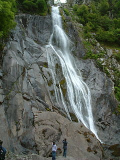
 Aber Falls (size shown by people below) |
|
| Abergwyngregyn shown within Gwynedd | |
| Population | 240 |
| OS grid reference | SH653726 |
| Community |
|
| Principal area | |
| Ceremonial county | |
| Country | Wales |
| Sovereign state | United Kingdom |
| Post town | LLANFAIRFECHAN |
| Postcode district | LL33 |
| Dialling code | 01248 |
| Police | North Wales |
| Fire | North Wales |
| Ambulance | Welsh |
| EU Parliament | Wales |
| UK Parliament | |
| Welsh Assembly | |
Abergwyngregyn is a village and community of historical note in Gwynedd, a county and principal area in Wales. Under its historic name of Aber Garth Celyn it was the seat of Llywelyn ap Gruffudd.
It is located at grid reference SH653726, adjacent to the A55, five miles (8 km) east of Bangor, eight miles (13 km) west of Conwy.
The Aber community, which covers an area of 2,970 hectares (11.5 sq mi), has a population of 240.
Abergwyngregyn, generally shortened to Aber, is a settlement of great antiquity and pre-conquest importance on the north coast of Gwynedd. Its boundaries stretch from the Menai Strait up to the headwaters of the Afon Goch and Afon Anafon. Protected to the east by the headland of Penmaenmawr, and at its rear by Snowdonia, it controlled the ancient crossing point of the Lafan Sands to Anglesey. A pre-Roman defensive enclosure, Maes y Gaer, which rises above Pen y Bryn on the eastern side of the valley, has far reaching views over Irish Sea with the Isle of Man visible on a clear day. The Roman road from Chester (Deva), linking the forts of Canovium (later name Conovium) and Segontium, crossed the river at this point.
...
Wikipedia

