Aberdeen, Mississippi
| Aberdeen, Mississippi | |
|---|---|
| City | |

Aberdeen City Hall (early 20th century)
|
|
| Motto: "A Great Place To Live, Work And Play" | |
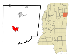
 Location of Aberdeen, Mississippi |
|
| Location in the United States | |
| Coordinates: 33°49′28″N 88°32′59″W / 33.82444°N 88.54972°WCoordinates: 33°49′28″N 88°32′59″W / 33.82444°N 88.54972°W | |
| Country | United States |
| State | Mississippi |
| County | Monroe |
| Government | |
| • Mayor | Cecil Belle |
| Area | |
| • Total | 11.0 sq mi (28.4 km2) |
| • Land | 10.7 sq mi (27.7 km2) |
| • Water | 0.2 sq mi (0.6 km2) |
| Elevation | 240 ft (73 m) |
| Population (2010) | |
| • Total | 5,612 |
| • Density | 510/sq mi (200/km2) |
| Time zone | Central (CST) (UTC-6) |
| • Summer (DST) | CDT (UTC-5) |
| ZIP code | 39730 |
| Area code(s) | 662 |
| FIPS code | 28-00180 |
| GNIS feature ID | 666129 |
Aberdeen is the county seat of Monroe County, Mississippi, United States. As of the 2010 census, the population was 5,612.
Located on the banks of the Tombigbee River, Aberdeen was one of the busiest Mississippi ports of the 19th century. Cotton was heavily traded in town, and for a time Aberdeen was Mississippi's second largest city. Today Aberdeen retains many historic structures from this period, with over 200 buildings on the National Register of Historic Places. In the spring of each year, Aberdeen hosts pilgrimages to its historic antebellum homes. The most prominent of these antebellum homes is The Magnolias, which was built in 1850.
Located just outside the city, Aberdeen Lock and Dam forms Aberdeen Lake, a popular recreational area. Aberdeen Lock and Dam is part of the Tennessee-Tombigbee waterway system.
In 1540, Hernando DeSoto's expedition were the first Europeans to travel through the vicinity of Aberdeen.
Aberdeen was first settled in 1834 and chartered as a town in 1837. In 1849, it became the county seat when Monroe County was formed.
Hiram Revels, the first African-American United States Senator, died on January 16, 1901, while attending a church conference in Aberdeen.
Aberdeen had a population of 3,708 in 1910. Its population had risen to 5,920 by 1950. Its population was 7,184 in 1980.
According to the United States Geological Survey, variant names are Dundee and New Aberdeen.
East Aberdeen is located at 33°49′18″N 88°30′59″W / 33.82167°N 88.51639°W, across the Tombigbee River from Aberdeen proper. Variant names for East Aberdeen are Howards Bluff, Howards Farm, Howards Ferry, Howards Store, Martins Bluff, and Murffs.
...
Wikipedia

