A53 road (Great Britain)
| A53 | |
|---|---|
 |
|
 |
|
| Route information | |
| Length: | 55.1 mi (88.7 km) |
| Major junctions | |
| North end: | Buxton |
| South end: | Shrewsbury |
| Location | |
|
Primary destinations: |
Leek Stoke-on-Trent Newcastle-under-Lyme |
| Road network | |
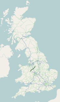
The A53 is a primary route in northern England, that runs from Buxton in Derbyshire to Shrewsbury in Shropshire.
The A53 begins in the centre of Buxton off the A6 road, before meeting the A515 road at a roundabout. Out of the town, it has a junction with the A54 road (to Congleton) before continuing in a south-westerly direction. It crosses the border into the county of Staffordshire, and after leaving the Peak District travels through the town of Leek. It meets the A523 road (to Macclesfield) and the A520 road (to Stone). It crosses the Caldon Canal and travels through the Stoke-on-Trent conurbation, including Hanley and Newcastle-under-Lyme, where it meets a number of major routes such as the A50 road (to Derby), the A500 "D-Road," the Winchester-Salford A34 and the A525 road (to Whitchurch). It crosses the M6 motorway and goes through the village of Ashley. It crosses the border into Shropshire, and bypasses the town of Market Drayton, and passes the Müller factory. It meets the A41 road (to Wolverhampton) at a roundabout, then meets the A442 road (to Telford). It goes through the village of Shawbury, before it terminates at its junction with the A49 road, 3 miles (4.8 km) north-east of Shrewsbury town centre at Battlefield.
...
Wikipedia

