A5103
| A5103 | |
|---|---|
 |
|
| Major junctions | |
| North end: | Manchester city centre and Hulme |
|
|
|
| South end: | M56 motorway junction 3a and Wythenshawe |
| Location | |
|
Primary destinations: |
Manchester |
| Road network | |
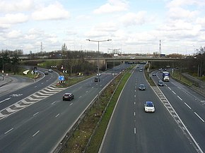
The A5103 is a major road in England. It runs from Piccadilly Gardens in Manchester city centre to junction 3 of the M56 motorway and is one of Manchester's principal routes.
The original scheme for a new road through the rural area south of Manchester was the design of the urban planner Richard Barry Parker, who envisaged the creation of a parkway — a broad, landscaped highway — to run from the new garden suburb of Wythenshawe, connecting it with Manchester City Centre.Manchester Corporation began construction of the new Princess Parkway in 1929 with a new bridge over the River Mersey. The new road was laid out as a dual carriageway for motor vehicles with a segregated tram track along the central reservation for Manchester Corporation Tramways to run trams into Manchester City Centre.
Princess Road/Princess Parkway was one of two new arterial roads into Manchester built by Manchester Corporation; the other was Kingsway, a few miles to the east, also built as a dual carriageway with reserved tram tracks along the middle. This layout was known as the 'Brodie' system, a new approach to road design that had been pioneered in Liverpool by John Alexander Brodie. The first tracks were laid out in the 1920s, terminating at Southern Cemetery; Manchester Corporation Transport planned to extend the tracks to Northenden and Wythenshawe, but following a change in transport policy in 1930, the Corporation invested in bus services instead. Manchester Corporation Tramways eventually ceased operation in 1949 and the tram tracks were removed.
...
Wikipedia

