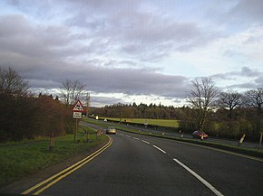
A456 road (Great Britain)
| A456 road | |
|---|---|

The A456 passing near Clent Hills
|
|
| Route information | |
| Length: | 40 mi (60 km) |
| Major junctions | |
| East end: |
Birmingham 52°28′45″N 1°54′23″W / 52.4791°N 1.9064°W |
|
|
|
| West end: |
Woofferton 52°18′44″N 2°42′17″W / 52.3122°N 2.7046°W |
| Location | |
|
Primary destinations: |
Kidderminster |
| Road network | |
Known as the Hagley Road in Birmingham, the A456 is a main road in England running between Central Birmingham and Woofferton, Shropshire, south of Ludlow. Some sections of the route, for example Edgbaston near Bearwood, are also the route of the Elan Aqueduct which carries Birmingham's water supply from the Elan Valley.
It is the only road in the West Midlands region that passes through all five of the regions' historical counties. The section from Central Birmingham to near its' junction with City Road being Warwickshire, then entering Staffordshire for a short distance until entering Worcestershire at its junction with Wolverhampton Road. Between Newnham and Burford the road enters Shropshire, and then enters Herefordshire for about the same distance, before entering Shropshire again at its' junction with the A49. Part of the historic Staffordshire/Worcestershire border runs along the road by Lightwoods Park, and today this is the boundary between the City of Birmingham and the Metropolitan Borough of Sandwell.
Much of the road is almost certainly medieval in origin. However, the road was laid out, essentially in its present form (except where there are modern bypasses) by a series of 18th century turnpike trusts.
From Birmingham to Blakedown section was the responsibility of one trust established in 1753 to improve roads from the market house in Stourbridge. Blakedown was then part of Hagley, giving rise to the name for it of 'Hagley Road'. Sections of the route have had other names. For example, the 1903 Ordnance Survey map shows the name "Beech Lane" by Lightwoods House west of Bearwood, and the area south of Hagley Road between Lordswood Road and Wolverhampton Road is still referred to as "Beech Lanes"
...
Wikipedia
