A4117 road (Great Britain)
| A4117 | |
|---|---|

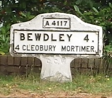
Milepost at Far Forest
|
|
| Route information | |
| Maintained by Shropshire Council & Worcestershire County Council |
|
| Length: | 15.0 mi (24.1 km) |
| Existed: | 1927 – present |
| History: | 1922—27 classified as the B4200 1979 shortened from 16 to 15 miles |
| Major junctions | |
| East end: | A456 at Fingerpost, near Bewdley |
| (junctions with the B4202, B4201, B4363, B4214 & B4364) | |
| West end: | A49T at the Ludlow bypass |
| Location | |
|
Primary destinations: |
none |
| Road network | |
The A4117 is a single-carriageway 'A road' in western England, largely in Shropshire, which passes through part of the Wyre Forest and Clee Hills.
It branches from the A456 2.2 miles (3.5 km) west of Bewdley, at a place called Fingerpost. Only the first 1.2 miles (1.9 km) of the route is in Worcestershire, as immediately after passing through the small village of Far Forest it passes over the Lem Brook and into Shropshire. Heading in a roughly westerly direction, it passes through Cleobury Mortimer, Hopton Wafers and Clee Hill Village. The road's destination is the town of Ludlow, where (since 1979) it ends at the Rocks Green roundabout on the A49 bypass. The route is 15.0 miles (24.1 km) long.
Notable bridges are where the road crosses the River Rea on the eastern edge of Cleobury Mortimer, the Hopton Brook at Hopton Wafers, and also the Ledwyche Brook at Henley near Ludlow.
The A4117 has no 'A road' junctions other than at its two ends. It has five junctions with 'B roads' however, all of which are at a terminus of the B road in question.
To the east of Cleobury Mortimer there are junctions with the B4202 road (which heads southwards into north Worcestershire), and the B4201 and B4363 roads (which head northwards into east Shropshire). Further along, the B4214 road runs from a junction with the A4117 at Cleehill, down a considerable decline to Tenbury Wells. At Henley, near the Ludlow bypass, the B4364 road from Bridgnorth joins the A4117.
...
Wikipedia

