A444 road (Great Britain)
| A444 | |
|---|---|

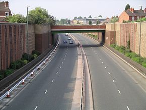
The A444 in Coventry showing the Heath Road bridge
|
|
| Route information | |
| Length: | 32 mi (51 km) |
| Major junctions | |
| South end: | Coventry |
|
|
|
| North end: | Burton upon Trent |
| Location | |
|
Primary destinations: |
Bedworth Nuneaton Twycross Appleby Magna Measham Swadlincote Stapenhill |
| Road network | |
The A444 is a primary road running between Coventry and Burton upon Trent in England, usually referred to as the "A treble four".
Starting at the junction of the A45 and A46 at Festival Island west of Baginton just south of Coventry, the road runs as a dual-carriageway one mile north to the Whitley junction. Here there is a break in the road and it starts again at the roundabout where the A428 Sky Blue Way/Binley Road and the B4110 Humber Road meet in Gosford Green just east of Coventry. From there it heads north as a dual-carriageway road, crossing the M6 at junction 3. It bypasses Bedworth to the west and heads into Nuneaton passing the George Elliot Hospital. The road continues into Nuneaton Town Centre and is notoriously bad for traffic during busy periods. The road then heads away from Nuneaton, through Weddington and crossing the A5 Watling Street.
Becoming a rural single carriageway road passing through Leicestershire countryside, it passes near to the outskirts of the village of Fenny Drayton and Farmland of the nearby Lindley Hall Farm that is the location of the geographical centre of England (per the Ordnance Survey). The road also passes near to the site of the Battle of Bosworth. It meets the end of the M42 south of Measham, eventually descending into Burton upon Trent to terminate on the A511.
...
Wikipedia

