Aßlar
| Aßlar | ||
|---|---|---|
|
||
| Coordinates: 50°35′N 08°28′E / 50.583°N 8.467°ECoordinates: 50°35′N 08°28′E / 50.583°N 8.467°E | ||
| Country | Germany | |
| State | Hesse | |
| Admin. region | Gießen | |
| District | Lahn-Dill | |
| Government | ||
| • Mayor | Roland Esch (FWG) | |
| Area | ||
| • Total | 43.57 km2 (16.82 sq mi) | |
| Elevation | 175 m (574 ft) | |
| Population (2015-12-31) | ||
| • Total | 13,672 | |
| • Density | 310/km2 (810/sq mi) | |
| Time zone | CET/CEST (UTC+1/+2) | |
| Postal codes | 35614 | |
| Dialling codes | 06441, 06443,06440, 06446 | |
| Vehicle registration | LDK | |
| Website | www.asslar.de | |
Aßlar (or Asslar, ![]() ) is a town near Wetzlar in the Lahn-Dill-Kreis in Hesse, Germany.
) is a town near Wetzlar in the Lahn-Dill-Kreis in Hesse, Germany.
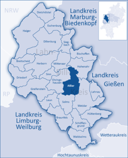
Aßlar lies on a foothill of the Westerwald range as well as on the river Dill, which empties into the Lahn in neighbouring Wetzlar, about 5 km to the southeast. It is also not far from the "three-state-border", a geographical point common to Hesse, North Rhine-Westphalia and Rhineland-Palatinate, lying to the west.
The constituent community of Werdorf also lies on the Dill, as do Klein-Altenstädten and Berghausen. Bechlingen, Oberlemp and Bermoll lie north of the main town, away from the river.
Aßlar borders in the north on the communities of Mittenaar and Hohenahr, in the east on the town of Wetzlar, in the south on the town of Solms, and in the west on the community of Ehringshausen (all in the Lahn-Dill-Kreis).
Aßlar is divided into the following communities:
Actually, the two communities of Werdorf and Berghausen lie so near each other that a casual observer would only perceive one community. Nevertheless, they are officially two of Aßlar's Stadtteile (roughly "wards" or perhaps "boroughs").
Aßlar had its first documentary mention in 783 in a donation document in the Lorsch codex (or Codex Laureshamensis in Latin).
...
Wikipedia


