33rd Street (Baltimore)

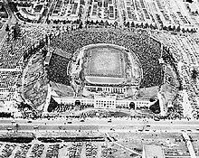
Baltimore Stadium on 33rd Street, 1944
|
|
| Owner | City of Baltimore |
|---|---|
| Location | Baltimore |
| Postal code | 21211, 21218 |
| West end | North Charles Street |
| East end | Hillen Road |
33rd Street, originally called Thirty-third Street Boulevard, is a long, wide, east-west parkway with a broad tree-shaded median strip. It is surrounded by 1920's-era "Daylight-styled" row houses with porches and small front yards. It was designed by the Frederick Law Olmsted Brothers firm, as part of their Baltimore Plan of 1904 and 1921 for establishing stream valley parks and connecting boulevards.
33rd Street is designated as "East" and "West" 33rd: the Johns Hopkins University campus and Wyman Park separate West 33rd — a six-block-long residential street which runs from Beach Avenue at the east to Falls Cliff Road at the west — from the main part of the street, East 33rd.
The street is served by part of the MTA bus routes 3 and 22.
33rd Street is bisected by the Johns Hopkins University campus, a notable institution of higher education, particularly renowned for its student research program and teaching hospital. Johns Hopkins also occupies the building formerly used by Eastern High School: a large, H-shaped, red brick, English Tudor Revival/Jacobethan styled building with limestone trim, constructed 1936–1938.
On the south side of 33rd street, between Loch Raven Boulevard and The Alameda, is Baltimore City College. It is an all-boys magnet public high school, the third oldest public secondary school in America (founded 1839 in downtown Baltimore, and eventually relocated to the 33rd Street building in 1928). City College is a massive stone structure, with a 150-foot bell tower in the Collegiate Gothic Revival style architecture. A historic landmark and the capstone of the Baltimore City Public Schools, City College boasts many famous alumni.
...
Wikipedia
