2010–2011 Queensland floods

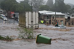
A woman trapped on the roof of her car awaits rescue during the Toowoomba flash flood
|
|
| Date | December 2010 – Jan 2011 |
|---|---|
| Location | Much of central and southern Queensland including Brisbane, Rockhampton, Emerald, Bundaberg, Dalby, Toowoomba, Roma, and Ipswich |
| Deaths | 38 dead and 6 missing (presumed dead) |
| Property damage | A$2.38 ($2,389,225,876) billion; 200,000 people were affected. |
|
|
|
|
|
A series of floods hit Queensland, Australia, beginning in December 2010. The floods forced the evacuation of thousands of people from towns and cities. At least 90 towns and over 200,000 people were affected. Damage initially was estimated at around A$1 billion before it was raised to $2.38 billion. The estimated reduction in Australia's GDP is about A$40 billion.
Three-quarters of the council areas within the state of Queensland were declared disaster zones. Communities along the Fitzroy and Burnett Rivers were particularly hard hit, while the Condamine, Ballone and Mary Rivers recorded substantial flooding. An unexpected flash flood caused by a thunderstorm raced through Toowoomba's central business district. Water from the same storm devastated communities in the Lockyer Valley. A few days later thousands of houses in Ipswich and Brisbane were inundated as the Brisbane River rose and Wivenhoe Dam used a considerable proportion of its flood mitigation capacity. Volunteers were quick to offer assistance, and sympathy was expressed from afar. A large mobilisation of the Australian Defence Force was activated and a relief fund created. The head of the recovery taskforce was Major General Michael Slater. The Queensland Reconstruction Authority (CEO was Graeme Newton) was formed to coordinate the rebuilding program beyond the initial task force, and a Commission of Inquiry was established to investigate all matters related to the floods.
The 2010–11 floods killed 38 people in Queensland. As of 26 January, an additional nine people were missing. The state's coal industry was particularly hard hit. The Queensland floods were followed by the 2011 Victorian floods which saw more than fifty communities in western and central Victoria also grapple with significant flooding.
Brisbane experienced major flooding in 1893 and 1974 as the Brisbane River broke its bank and inundated low-lying areas. Towns including St George and Theodore had dealt with major flooding earlier in 1996. The floods were a result of heavy rainfall caused by Tropical Cyclone Tasha that combined with a trough during the peak of a La Niña Modoki event. The 2010 La Niña Modoki weather pattern, which brings wetter conditions to eastern Australia, was the strongest since 1973. This La Niña event caused a prolonged event of heavy rainfall over Queensland river catchments. Record or near to record sea surface temperatures were recorded off the Queensland coast in late 2010. December 2010 was Queensland's wettest on record, with record high rainfall totals set in 107 locations for the month. The state average rainfall level of 209.45 millimetres (8.25 in) exceeded the previous record of 200.1 millimetres (7.88 in) set in 1975. 2010 was also recorded as the state's wettest spring since 1900 and the Australian continent's third wettest year. Climate scientist Kevin Trenberth thought climate change was a contributing factor in the unusually high precipitation rates. He attributed a half-degree Celsius rise in ocean temperatures around Australia to global warming which produces extra water vapour and intensifies the monsoon. Other scientists say that it is too early to draw such a conclusion. Assertions were also made by Professor Hubert Chanson, an expert in dam and reservoir engineering with extensive firsthand knowledge of the Wivenhoe system, that mismanagement of the Wivenhoe Dam might be a contributor to the some flooding in the lower Brisbane valley. While an expert engineer, Michael O'Brien - a senior manager of an ASX-listed resources company and an outside consultant evaluating cause - agrees that "massive releases of water from Wivenhoe Dam on Tuesday, January 11, did indeed produce most of the flooding in the Brisbane River the following afternoon, with a peak in the early hours of Thursday morning, January 13. The dam's releases into the Brisbane River also caused the Bremer River, which winds through the city of Ipswich, and the Lockyer Creek to back up and cause much of the flooding outside Brisbane." This was corroborated by a panel of engineers hired by Insurance Council of Australia. O'Brien also found that the Wivenhoe Dam and Somerset Dam did not hold the maximum capacity they were capable of holding during the crisis period, which would have significantly alleviated flooding. Only one source, Neal Ashkanasy, who specialises in social and organisational psychology (and 35 years ago was involved in the design of Wivenhoe Dam), found fault with these results and instead finds that the dam was operated correctly throughout the time of the storm and the flood that followed, saying the "dam was run with outstanding precision."
...
Wikipedia
