2009–10 North American winter

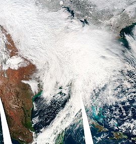
The first of 3 blizzards to impact the Northeast in early February 2010.
|
|
| Astronomical winter | December 21 – March 20 |
|---|---|
| Meteorological winter | December 1 – February 28 |
The 2009–10 North American winter refers to winter as it occurred across the continent from late 2009 through early 2010. While there is no well-agreed-upon date used to indicate the start of winter in the Northern Hemisphere, there are two definitions of winter which may be used. Based on the astronomical definition, winter begins at the winter solstice, which in 2009 occurred on December 21, and ends at the March equinox, which in 2010 occurred on March 20. Based on the meteorological definition, the first day of winter is December 1 and the last day February 28. Both definitions involve a period of approximately three months, with some variability.
On October 15, 2009, the National Oceanic and Atmospheric Administration's Climate Prediction Center issued its U.S. Winter Outlook. Due to a strengthening El Niño, winter weather was expected to be affected by this. Warmer-than-average temperatures were favored across much of the western and central U.S., especially in the north-central states from Montana to Wisconsin. Below-average temperatures were expected across the Southeast and mid-Atlantic from southern and eastern Texas to southern Pennsylvania and south through Florida. Above-average precipitation is expected in the southern border states, especially Texas and Florida. Recent rainfall and the prospects of more should improve current drought conditions in central and southern Texas. The rest of the country fell into the equal-chance zone.
On December 16, meteorologists identified a storm forming in the Gulf of Mexico. It produced record rainfall in regions of Texas and had the potential to strengthen as it moved through Georgia and Florida and further north. Weather models accurately predicted that this storm would meet with cold air while retaining its heavy precipitation. By the afternoon of December 19, the large, low pressure region had moved off the East coast, intensifying and bringing heavy snow to the major Mid-Atlantic cities.Blizzard warnings were issued in Washington, D.C., Baltimore, and Long Island. As the storm moved northward along the East coast, at one point it measured 500 miles (800 km) across 14 states. The storm produced whiteout conditions and dumped about 16–20 inches (41–51 cm) of snow in major cities along the Eastern seaboard.
...
Wikipedia
