2005 Azores subtropical storm
| Subtropical storm (SSHWS/NWS) | |

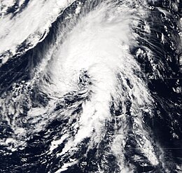
The storm at peak intensity near the Azores on October 4
|
|
| Formed | October 4, 2005 |
|---|---|
| Dissipated | October 5, 2005 |
| Highest winds |
1-minute sustained: 50 mph (85 km/h) |
| Lowest pressure | 997 mbar (hPa); 29.44 inHg |
| Fatalities | None reported |
| Areas affected | Azores |
| Part of the 2005 Atlantic hurricane season | |
The 2005 Azores subtropical storm was the nineteenth nameable storm of the record-breaking 2005 Atlantic hurricane season. It was not officially named by the National Hurricane Center as it was operationally classified as a non-tropical low. The storm developed in the eastern Atlantic Ocean out of a low-pressure area that gained subtropical characteristics on October 4. The storm was short-lived, crossing over the Azores later on October 4 before becoming extratropical again on October 5. No damage or fatalities were reported. After being absorbed into a cold front, the system went on to become Hurricane Vince, which affected the Iberian Peninsula.
Months after the hurricane season, when the National Hurricane Center was performing its annual review of the season and its named storms, forecasters Jack Beven and Eric Blake identified this previously unnoticed subtropical storm. Despite its unusual location and wide wind field, the system had a well-defined center convecting around a warm core—the hallmark of a subtropical storm.
The system originated out of an upper-level low just west of the Canary Islands on September 28. The low organized itself over the next several days, producing several bursts of convection. While remaining non-tropical with a cold core it moved gradually west to northwest. On October 3, it became a broad surface low about 400 nautical miles (460 mi, 740 km) southwest of São Miguel Island in the Azores. Early on October 4, convection increased as the surface low organized itself, and the system became a subtropical depression. Around the same time, the depression turned northeast into a warm sector ahead of an oncoming cold front and strengthened into a subtropical storm. The system continued to track northeast and strengthened slightly, reaching its peak intensity of 50 mph (85 km/h) as it approached the Azores that evening. After tracking through the Azores, the storm weakened slightly as it moved to the north-northeast. Through an interaction with the cold front early on October 5 the subtropical storm became extratropical. The system was fully absorbed by the front later that day. The newly absorbed system would separate from the dissolving frontal system and become Subtropical Storm Vince on October 8.
...
Wikipedia
