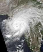
1982 North Indian Ocean cyclone season
| Category 4 tropical cyclone (SSHWS) | |
| Duration | April 30 – May 5 |
|---|---|
| Peak intensity | 230 km/h (145 mph) (1-min) 914 hPa (mbar) |
| Tropical storm (SSHWS) | |
| Duration | May 30 – June 4 |
|---|---|
| Peak intensity | 100 km/h (65 mph) (1-min) 983 hPa (mbar) |
| Tropical storm (SSHWS) | |
| Duration | October 13 – October 16 |
|---|---|
| Peak intensity | 95 km/h (60 mph) (1-min) 986 hPa (mbar) |
| Tropical storm (SSHWS) | |
| Duration | October 17 – October 19 |
|---|---|
| Peak intensity | 95 km/h (60 mph) (1-min) 987 hPa (mbar) |
| Category 2 tropical cyclone (SSHWS) | |
| Duration | November 4 – November 9 |
|---|---|
| Peak intensity | 155 km/h (100 mph) (1-min) 952 hPa (mbar) |
The 1982 North Indian Ocean cyclone season was part of the annual cycle of tropical cyclone formation. The season has no official bounds but cyclones tend to form between April and December. These dates conventionally delimit the period of each year when most tropical cyclones form in the northern Indian Ocean. There are two main seas in the North Indian Ocean—the Bay of Bengal to the east of the Indian subcontinent and the Arabian Sea to the west of India. The official Regional Specialized Meteorological Centre in this basin is the India Meteorological Department (IMD), while the Joint Typhoon Warning Center (JTWC) releases unofficial advisories. An average of five tropical cyclones form in the North Indian Ocean every season with peaks in May and November. Cyclones occurring between the meridians 45°E and 100°E are included in the season by the IMD.
On April 30 the monsoon trough spawned a tropical depression in the western Bay of Bengal. It tracked northeastward, becoming a tropical storm on the 1st and a cyclone on the 2nd. Its movement became more to the east, and the cyclone continued to quickly intensify, reaching a peak of 145 mph winds just before landfall. The small and compact cyclone hit southern Myanmar on the 4th, and it dissipated the next day over land. Moderate to heavy damage was experienced, but advance warning kept the death toll at only five in an area where hundreds to thousands of deaths are relatively common.
Tropical Depression 2B developed from the monsoon trough in the central Bay of Bengal on May 30. It headed northeastward, becoming a tropical storm later that day and reaching a peak of 65 mph winds on the 31st. The storm turned to the northwest, where it weakened to a tropical depression. It restrengthened, and hit near Paradip, India on the 3rd as a 65 mph tropical storm. The storm brought heavy flooding amounting to 140 casualties and destroying over 500,000 homes.
...
Wikipedia


