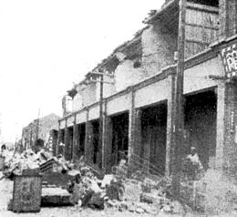
1935 Shinchiku-Taichū earthquake
 |
|
| Date | April 21, 1935 |
|---|---|
| Magnitude | 7.1 ML |
| Depth | 3 km (2 mi) |
| Epicenter |
24°18′N 120°45′E / 24.30°N 120.75°ECoordinates: 24°18′N 120°45′E / 24.30°N 120.75°E Sansa Village, Byōritsu District, Shinchiku Prefecture, Japanese Taiwan (modern-day Sanyi, Miaoli County, Taiwan) |
| Areas affected | Taiwan island, Empire of Japan |
| Casualties | 3,276 killed, 12,053+ injured |
The 1935 Shinchiku-Taichū earthquake occurred with a Richter magnitude of 7.1 in April 1935 with its epicenter in Shinchiku Prefecture, Japanese Taiwan. It was the deadliest earthquake in Taiwan's recorded history, claiming 3,276 lives and causing extensive damage. Twelve seconds after the mainshock, an aftershock of ML 6.0 occurred, centered on Gabi Village (present-day Emei Township, Hsinchu County).
The initial shock happened at 06:02 local time on April 21, 1935. The epicentre was in the village of Sansa (三叉?), Byōritsu District, Shinchiku Prefecture (modern-day Sanyi, Miaoli), with the quake measuring 7.1 on the Richter magnitude scale. The quake was felt all over Taiwan apart from Hengchun on the southern tip of the island, as well as in Fuzhou and Xiamen, China, across the Taiwan Strait.Soil liquefaction was observed in various locations, and a 3 m (10 ft) drop between the two sides of the fault was in evidence at Gabi Village. The most serious damage from the quake was located in Shinchiku Prefecture and Taichū Prefecture (present-day Miaoli County and Taichung) over a 135 square kilometres (52 sq mi) area.
A number of aftershocks followed the main quake, with the largest registering 6.0 with an epicentre at Gabi.
The earthquake was the deadliest in Taiwan's recorded history. The official reports cite the following figures for deaths, injuries and damage:
...
Wikipedia

