1896 Meiji-Sanriku earthquake

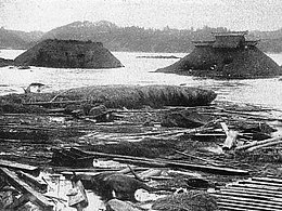
Devastation caused by the tsunami at Sanriku.
|
|
| Date | June 15, 1896 |
|---|---|
| Origin time | 19:32:30 JST (UTC+09:00) |
| Magnitude | 8.5 Mw, 7.2 Ms |
| Depth | shallow |
| Epicenter | 39°30′N 144°00′E / 39.5°N 144.0°ECoordinates: 39°30′N 144°00′E / 39.5°N 144.0°E |
| Type | Megathrust |
| Areas affected | Japan, United States |
| Total damage | Tsunami |
| Tsunami | Up to 38.2 m (125 ft) in Ryori, Kesen, Iwate, Tōhoku |
| Casualties | 22,066 people dead or missing |
The 1896 Sanriku earthquake was one of the most destructive seismic events in Japanese history. The 8.5 magnitude earthquake occurred at 19:32 (local time) on June 15, 1896, approximately 166 kilometres (103 mi) off the coast of Iwate Prefecture, Honshu. It resulted in two tsunamis which destroyed about 9,000 homes and caused at least 22,000 deaths. The waves reached a record height of 38.2 metres (125 ft); more than a meter lower than those created after the 2011 Tōhoku earthquake which triggered the 2011 Japanese nuclear accidents.
Seismologists have discovered the tsunamis' magnitude (Mt = 8.2) was much greater than expected for the estimated seismic magnitude. This earthquake is now regarded as being part of a distinct class of seismic events, the tsunami earthquake.
The epicenter lies just to the west of the Japan Trench, the surface expression of the west-dipping subduction zone. The trench forms part of the convergent boundary between the Pacific and Eurasian plates.
The unusual disparity between the magnitude of the earthquake and the subsequent tsunami may be due to a combination of forces:
Scientists believe the effect of subducted sediment beneath the accretionary wedge was responsible for a slow rupture velocity. The effects of a 20° dipping fault along the top of the subducting plate was found to match both the observed seismic response and tsunami, but required a displacement of 10.4 m. The displacement was reduced to a more reasonable value after the extra uplift caused by the deformation of sediments in the wedge and a shallower fault dip of 10° was considered. This revised fault model gave a magnitude of Mw=8.0-8.1. A figure much closer to the estimated actual tsunami magnitude. A magnitude of 8.5 on the moment magnitude scale has also been estimated for this event.
...
Wikipedia

