Šipovo
|
Šipovo Шипово |
||
|---|---|---|

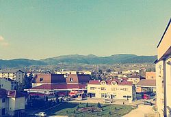
View on Šipovo from new Municipality building
|
||
|
||
 Location of Šipovo within Republika Srpska, Bosnia and Herzegovina |
||
| Coordinates: 44°28′N 17°08′E / 44.467°N 17.133°E | ||
| Country |
|
|
| Entity |
|
|
| Government | ||
| • Mayor | Milorad Ćirko (NDS) [1] | |
| Area | ||
| • Total | 553,41 km2 (21,367 sq mi) | |
| Population (2013 census) | ||
| • Total | 10,820 | |
| • Density | 19,6/km2 (510/sq mi) | |
| Time zone | CET (UTC+1) | |
| • Summer (DST) | CEST (UTC+2) | |
| Area code(s) | 50 | |
Šipovo (Serbian Cyrillic: Шипово) is a town and municipality in central Bosnia and Herzegovina. It is situated in the western part of the Republika Srpska entity and the southern part of the Bosanska Krajina region. The municipality covers an area of 510 km2 (197 sq mi), much of which is forested.
The Glogovac monastery of the Serb Orthodox Church is near the town. [2]
It is located between municipalities of Mrkonjić Grad in the west, Jezero in the north, Jajce and Donji Vakuf in the east, and Kupres (Republike Srpske) and Glamoč in the south.
In the broader geographical sense, the town of Šipovo is located at 44 17’ north and 170 06’ east, in the zone of temperately continental climate.
In the narrower geographical sense, Šipovo is located in south-eastern part of Republika Srpska, with the total area of 510 km2 (197 sq mi), and with population of 11,000. The population consists of 95% of Serbs and 5% of Bosniacs.
Šipovo is a mountain area, intersected in the west-east direction by the Pliva River, whose length is about 30 kilometres of the air line, and in the south-north direction by the Janj River, whose length is about 35 kilometres of the air line. Besides these two rivers, the Šipovo area is also intersected by three small rivers – Sokočnica, Lubovica and Volarica. The area around the mouth of the Janj River to the Pliva River is both plain and hilly, with the height of around 440 metres above sea level. It gradually slopes up to become the mountain area whose highest mountains are Vitorog (1906 m) in the south, Lisina (1335 m) in the north, Gorica (1267 m) in the east, and Čardak (1452 m) in the west.
...
Wikipedia

