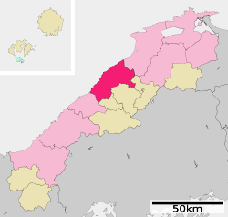
Ōda, Shimane
|
Ōda 大田市 |
||
|---|---|---|
| City | ||
|
||
 Location of Ōda in Shimane Prefecture |
||
| Location in Japan | ||
| Coordinates: 35°11′N 132°30′E / 35.183°N 132.500°ECoordinates: 35°11′N 132°30′E / 35.183°N 132.500°E | ||
| Country | Japan | |
| Region | Chūgoku (San'in) | |
| Prefecture | Shimane Prefecture | |
| Government | ||
| • Mayor | Soichi Takegoshi (since 2005) | |
| Area | ||
| • Total | 436.11 km2 (168.38 sq mi) | |
| Population (January 1, 2012) | ||
| • Total | 38,837 | |
| • Density | 89/km2 (230/sq mi) | |
| Symbols | ||
| • Tree | Prunus mume | |
| • Flower | Phododendron molle | |
| Time zone | Japan Standard Time (UTC+9) | |
| City hall address | 1111 Ōdaguchi, Ōda-machi, Ōda-shi, Shimane-ken 694-0064 |
|
| Website | www |
|
Ōda (大田市 Ōda-shi?) is a city located on the coast of the Sea of Japan in Shimane Prefecture, Japan.
As of January 1, 2012, the city has an estimated population of 38,837, with 16,264 households and a population density of 89.05 persons per km². The total area is 436.11 km². The city was founded on January 1, 1954. Ōda is home to the Iwami Ginzan Silver Mine, a World Heritage Site.
Located in the central coastal portion of Shimane Prefecture, Ōda borders the Sea of Japan to the north and the Chūgoku Mountains to the south. Mount Sanbe (1,126 metres (3,694 ft)), part of Daisen-Oki National Park, is a double volcano of the Hakusan Volcanic Zone, and is situated to the southeast of the city.
Ōda remains a center of agricultural production. The city is a center for dairy farms. Additionally, the city is known for its roof tile industry, produced since early times as Iwami gawara, or kawara Japanese roof tiles of Iwami.
Ōda is serviced by two transportation networks. The first is JR West Sanin Main Line, connecting Ōdashi Station to Tottori through Yonago and Matsue to the east, and connecting along the coast to Hamada and Masuda to the west.
...
Wikipedia


