Útila
| Utila | |
|---|---|

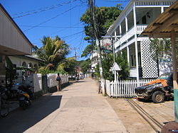
Typical road near the Munchies Restaurant, a historic building
|
|
| Location in Honduras | |
| Coordinates: 16°06′N 86°56′W / 16.100°N 86.933°W | |
| Country | Honduras |
| Department | Islas de la Bahía |
| Area | |
| • Total | 45 km2 (17 sq mi) |
| Elevation | 74 m (243 ft) |
| Population (2015) | |
| • Total | 4,160 |
| • Density | 92/km2 (240/sq mi) |
|
Honduras
|
|
| Location | Isla de Útila Bay Islands |
|---|---|
| Coordinates | 16°05′10.0″N 86°53′52.6″W / 16.086111°N 86.897944°W |
| Foundation | piles |
| Construction | concrete mast |
| Tower shape | square prism mast |
| Markings / pattern | red mast with horizontal white band |
| Height | 15 metres (49 ft) |
| Focal height | 15 metres (49 ft) |
| Light source | solar power |
| Range | 4 nautical miles (7.4 km; 4.6 mi) |
| Characteristic | F W |
| Admiralty number | J6003 |
| NGA number | 16448 |
Utila (Isla de Utila) is the smallest of the Honduras' major Bay Islands, after Roatán and Guanaja, in a region that marks the south end of the Mesoamerican Barrier Reef System, the second-largest in the world.
The eastern end of the island is capped by a thin veneer of basaltic volcanic rocks, erupted from several pyroclastic cones including 74 m (243 ft) Pumpkin Hill which forms the highest point on the island. It has been documented in history since Columbus' fourth voyage, and currently enjoys growing tourism with emphasis on recreational diving and is known as one of the world's best dive locations. The people of Utila are of English, Dutch, German descent.
Archeological, historical and ethnographic evidence of the Bay Islands indicates that they were inhabited well before the Europeans arrived, as long ago as 600AD by a pre-Columbian culture known as the Paya. The Paya may have entered Central America in the great North to South America migration in 5,000 BC, although to the contrary, linguistic studies indicate that the Paya may have been descendants of South American tribes.Christopher Columbus, on his fourth voyage to the new world, landed on the island of Guanaja on 30 July 1502, after encountering a small fleet of dugout canoes destined from the mainland to the Bay Islands. These vessels were filled with cotton cloth, maize, cacao, beans, copper goods and wooden swords with sharp flint edges, and on this meeting one dugout canoe carrying 25 men, women and children was captured. On land, Columbus encountered a fairly large population of Paya whom he believed to be cannibals. In 1516, licensed slavers were sent to the Islands under the authority of Diego Velasquez and captured 300, killing others who put up resistance. The slaving vessel returned to Havana harbour, Santiago de Cuba, where it was taken over by the Paya who demanded repatriation. On hearing that the Paya had been repatriated, Velasquez commissioned two ships back which then captured 400 Paya on Utila and on one of the other islands, and during this raid 100 Paya were reported to have been killed. After their capture, this and future shipments of Paya slaves were forced to work in mines, farm sugar cane plantations and tend livestock on Santiago de Cuba, and were also sent to work in the gold and silver mines of Mexico.
...
Wikipedia


