Guanaja
| Guanaja | |
|---|---|
 ]] ]]
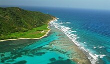
A NASA satellite photograph of Guanaja.]]
|
|
| Location in Honduras | |
| Coordinates: 16°28′N 85°53′W / 16.467°N 85.883°W | |
| Country | Honduras |
| Department | Islas de la Bahía |
| Area | |
| • Total | 50 km2 (20 sq mi) |
| Population (2015) | |
| • Total | 5,538 |
| • Density | 110/km2 (290/sq mi) |

The lighthouse is at the end of the land
|
|
|
Honduras
|
|
| Coordinates | 16°29′53.3″N 85°49′01.8″W / 16.498139°N 85.817167°W |
|---|---|
| Foundation | concrete basement |
| Construction | steel post |
| Tower shape | cylindrical post with light |
| Markings / pattern | white and red horizontal band post |
| Height | 12 metres (39 ft) |
| Focal height | 22 metres (72 ft) |
| Light source | solar power |
| Range | 19 nautical miles (35 km; 22 mi) |
| Characteristic | Fl W 9s. |
| Admiralty number | J6010.5 |
| NGA number | 16477 |
| ARLHS number | HON-006 |
Guanaja is one of the Bay Islands of Honduras and is in the Caribbean. It is about 70 kilometres (43 mi) off the north coast of Honduras, and 12 kilometres (7.5 mi) from the island of Roatan. One of the cays off Guanaja, also called Guanaja or Bonacca or Low Cay (or just simply, The Cay), is near the main island, and contains most of the approximately 10,000 people who live in Guanaja. The densely populated cay has been described as the Venice of Honduras because of the waterways that run through it. The other two main settlements on Guanaja are Mangrove Bight and Savannah Bight. Smaller settlements include East End and North East Bight.
The primary source of income for the islanders is fishing and shrimping. Tourism is confined to a handful of small resorts that cater to divers, snorkelers and adventure travellers. The island's warm, clear waters support an extensive coral reef that is part of the Mesoamerican Barrier Reef and second only to the Great Barrier Reef off the coasts of Australia. Currently, there is still access to fresh water on Guanaja, and several waterfalls can be seen.
Guanaja was discovered by Christopher Columbus on his fourth voyage in 1502. Notably, this was the first time he came across cacao, which is the core of chocolate. He landed on Soldado Beach on the north side of the island. In later years Cayman Islanders settled in the Bay Islands, which explains the diffusion of Spanish and English language.
Homer Hickam, author of Rocket Boys/October Sky, was one of the first scuba explorers of Guanaja, first visiting in 1973. Along with a team of other scuba explorers, he extensively mapped the reef system around the island for sport divers. He still owns property on the northeast end of the island.
In late October 1998, most of the buildings and homes on the island were destroyed by Hurricane Mitch. The islanders have since rebuilt, and although there are still repercussions to the economy from Mitch, tourism has been recovering. The majority of the mangrove and pine forests, which were destroyed as a direct consequence of the passage of the hurricane sweeping across the island for two days, are slowly making a comeback.
Guanaja, also known as:
...
Wikipedia


