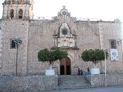
Álamos
| Álamos | |
|---|---|
 |
|
| Location in Mexico | |
| Coordinates: 27°1′39″N 108°56′24″W / 27.02750°N 108.94000°W | |
| Country |
|
| State | Sonora |
| Municipality | Álamos |
| Founded | Late 17th century |
| Population (2005) | |
| • Total | 24,493 |
| Time zone | MST (UTC-7) |
| Postal code | 85760 |
| Area code(s) | 647 |
Álamos (Spanish ![]() ['alamos] is a town in Álamos Municipality in the Mexican state of Sonora, in northwestern Mexico.
['alamos] is a town in Álamos Municipality in the Mexican state of Sonora, in northwestern Mexico.
The Municipality of Álamos derives its name from the Álamo tree. Several impressive specimens are found in one of its two principal plazas, the Alameda. The nearby pueblito, El Sabinito, located within the Municipality, likewise derives its name from a tree, the Sabino.
The area was named by the conquistador Francisco Vásquez de Coronado . His expedition of 1540 camped at the confluence of the two major arroyos (Escondido and the Aduana) of present-day Alamos and made reference to local geographical landmarks, including two large rock formations on Mt. Alamos, Los Frailes or 'the monks' in English. The church records date to 1682 and the village was incorporated in 1685. Alamos became the capital of the then state of Occidental in the early 1800s, which encompassed today's state of Sonora, the northern portion of the state of Sinaloa, as well as some of the Baja California and southern Arizona. . Álamos was the northern-most “Silver City” in Mexico and although it has much in common, architecturally, with Mexico's other “Silver Cities” it has not succumbed to large-scale commercialism and has managed to retain the charm and pace of earlier times.
A major expedition departed Alamos in 1775, led by Juan Bautista de Anza II to discover a route to Alta California, and creating the Presidio of Monterey. The Anza expedition had nearly 300 members, of which about half were from Alamos. The trek was heavily financed by the wealthy silver mine owners of Alamos.
...
Wikipedia

